Poor outlook ahead of strong cold outbreak

South Australian Surf Forecast by Craig Brokensha (issued Monday May 23rd)
Best Days: South Coast Saturday and Sunday mornings before winds become too strong
Features of the Forecast (tl;dr)
- Tiny surf over the coming days with NE winds tomorrow, NE tending N/NW-N Wed and W/NW tending SW winds Thu
- Inconsistent, tiny W groundswell tomorrow PM and Wed AM on the Mid
- Inconsistent mid-period SW swell building Fri PM, with a better pulse Sat, easing Sun
- W/NW tending SW winds on Fri, strengthening N/NW Sat and strengthening N Sun
- Junky N/NW windswell Sat and Sun
- Mix of W/SW and SW swell building Mon/Tue with strong W/NW winds Mon and strong W/SW Tue
Recap
Clean conditions but small, leftover surf across the South Coast, best suited to the swell magnets. The Mid Coast was clean each morning but tiny.
Today conditions are clean again with small 1-2ft leftovers across Middleton, best on the exposed breaks again with flat conditions across the Mid Coast.
This week and weekend (May 24 – Jun 3)
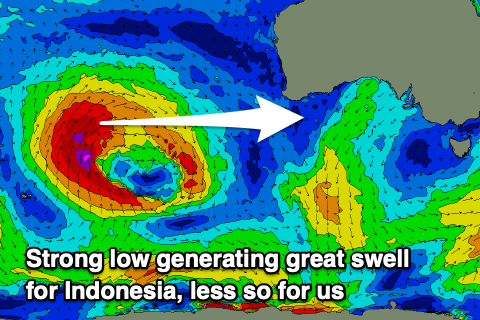
It's good to be back behind the forecasting desk, but heading into the final week of May, the outlook is for a slow period as a large, blocking high moves slowly east. There's been no significant polar frontal activity on the southern or south-west flank of the high and a strong mid-latitude storm firing up in the Indian Ocean was too far north to generate any major swell for us.
 There might a tiny hint of inconsistent W'ly groundswell on the Mid Coast from this low later tomorrow and Wednesday morning but only to 1ft max. The South Coast will bottom out with 1ft surf due across Middleton tomorrow through Thursday. Winds will be fresh out of the NE tomorrow, with NE tending N-N/NW winds on Wednesday ahead of shallow change Thursday bringing W/NW tending SW winds.
This change will be linked to a weakening low moving in from the west though not bringing much in the way of new swell at all, with a 1ft wave due into Thursday afternoon and Friday on the Mid Coast.
The South Coast will be tiny, but a new, inconsistent mid-period SW swell is due to arrive Friday afternoon, ahead of a secondary pulse on Saturday.
The source of these swells will be a poorly structured and distant polar low that's currently sitting over and just east of the Heard Island region.
A patchy fetch of strong to gale-force W/NW-NW winds will generate the increase in size Friday afternoon, with weaker trailing W/SW winds producing the slightly better but weaker swell for Saturday, easing Sunday.
Inconsistent 2ft sets are due across Middleton Friday afternoon, with 2-3ft sets Saturday, easing Sunday from 2ft again. The Mid Coast isn't expected to see any size from this source.
 Winds on Friday morning should be W/NW again, shifting SW through the day while a broad, cold and significant low developing high in the Bight will see winds shift to the N/NW on Saturday, strengthening through the day (kicking up 1-2ft of NW windswell on the Mid Coast), with Sunday seeing moderate N tending stronger N'ly winds.
The low is due to move through on Monday/Tuesday, bringing strong W/NW winds on the former, strong W/SW on the latter.
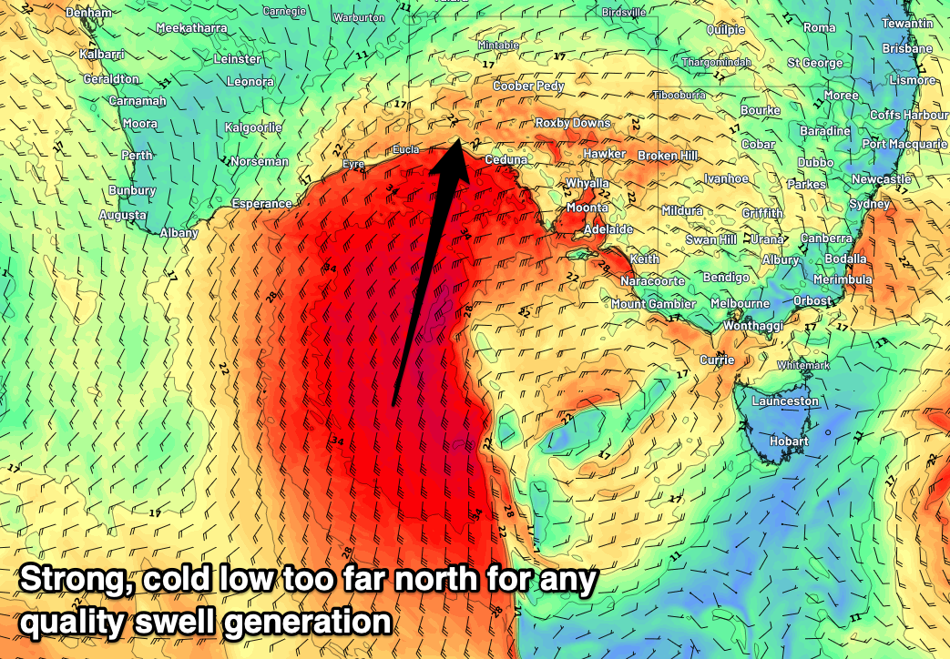
Swell wise the low isn't ideal for any quality swell generation with a significant fetch of severe-gale to storm-force SW winds due to be slammed into the West Coast before the low tracks north, and then across us on Monday/Tuesday.
This will see poor locally generated swell across both coasts, with a better swell producer due later week. More on this Wednesday.
Comments
Are the surf forecast tables for SA a bit out of whack? I could be misinterpreting or maybe I missed the memo. Cheers