Fun mornings of surf for the South Coast

South Australian Surf Forecast by Craig Brokensha (issued Wednesday March 23rd )
Best Days: Tomorrow morning South Coast, Saturday morning South Coast, Sunday South Coast
Features of the Forecast (tl;dr)
- Moderate sized mid-period S/SW swell tomorrow with light E/NE tending S/SE winds
- Easing S/SW swell Fri with light-moderate S/SE-SE tending fresh S/SE winds
- New S/SW groundswell for Sat with light E/NE tending S/SE winds
- Reinforcing S/SW groundswell arriving late morning Sun with light N/NE tending weak S/SE winds
- Easing surf Mon with S'ly winds
Recap
Variable winds and improving conditions across the South Coast through yesterday and on the small side with 2ft sets across Middleton. The Mid Coast offered tiny 1ft waves.
Today a new pulse of background W/SW swell is providing 1-1.5ft sets on the Mid Coast magnets with clean conditions, bumpy and choppy down South with a S/SE breeze.

Tiny runners today
This week and weekend (Mar 24 - 27)
We've got fun pulses of swell during the coming period and with generally workable winds across the South Coast.
An initial increase in mid-period SW swell tomorrow has been generated by a broad but relatively weak frontal system pushing up and across Tasmania today.
This should provide good 3ft surf across Middleton tomorrow with tiny 0.5-1ft sets across the Mid Coast. Winds look light from the E/NE tomorrow morning down South, E/SE on the Mid before sea breezes kick in, average Friday with a slight drop in swell and light to moderate S/SE-SE morning winds.
We then look at our S/SW groundswell for Saturday, followed now by a reinforcing groundswell on Sunday from a similar direction.
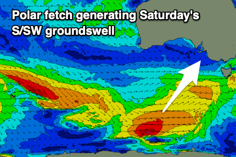 These swells will be generated by a healthy polar frontal progression that's started to take shape under the country with a pre-frontal fetch of strong W/NW winds that's pushing under the Bight due to be followed by strong to gale-force W/SW winds on the polar shelf.
The first pulse of S/SW groundswell should be in the water by Saturday morning with 3ft to occasionally 4ft sets across Middleton (tiny on the Mid Coast). The secondary pulse of swell looks to be a little later through the day Sunday, arriving late morning and peaking through the afternoon. This should maintain 3ft to occasionally 4ft sets across Middleton, then easing from 3ft on Monday morning.
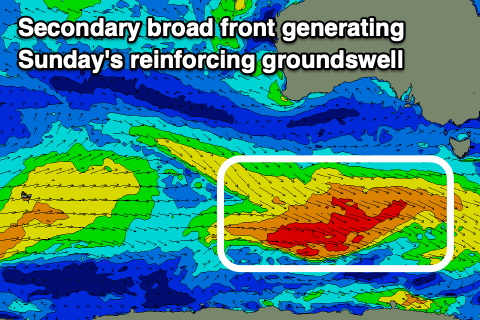 Winds will shift light E/NE on Saturday morning creating clean and slightly peaky faces, with Sunday looking the pick under a variable N/NE offshore ahead of relatively weak sea breezes. Come Monday a trough will bring an overnight change Sunday, leaving poor and fresh S'ly winds across both coasts.
Longer term the outlook is mixed with a broad, strong mid-latitude low due to form off the Western Australian coast on the weekend, putting a small block across our swell windows, while a high sliding in under the low early next week looks to be followed by polar fronts. This should generate some new SW groundswell mid-late week but with SE winds. More on this Friday.
Comments
Weekend warriors are frothing