Make the most of the current waves

South Australian Surf Forecast by Craig Brokensha (issued Friday October 15th)
Best Days: Today on the Mid Coast, Mid Coast for the keen early tomorrow, South Coast Sunday morning, beginners Sunday on the Mid
Features of the Forecast (tl;dr)
- Easing W/SW groundswell tomorrow with a new inconsistent SW groundswell. Fresh S/SW winds (S/SE early on the Mid and likely W/NW early down South)
- Easing SW groundswell Sun with N/NE tending SE winds down South (E/NE tending S/SW on the Mid)
- Building S/SW groundswell Mon with strengthening S/SE winds, lighter and more E early
- Easing S/SW groundswell and S/SE windswell Tue with gusty E/NE tending E/SE winds
- Small fading surf Wed with strong NE winds
Recap
What a dynamic couple of days. We saw a good pulse of W/SW groundswell kicking late on Wednesday but peaking yesterday as a slow moving mid-latitude low moved in from the west, bringing favourable offshore winds across both coasts and fun 2-3ft surf on the Mid Coast, 2-3ft across Middleton to Goolwa owing to the westerly direction.
Conditions deteriorated into the afternoon down South with stronger S'ly winds, still workable on the Mid but bumpy.
This morning we've got E/SE-SE winds feeding into the low, creating peaky clean 2-3ft waves on the Mid Coast, bumpy down South and to 2-3ft across Middleton, but we've now seen the low push in across us, bringing strengthening S/SW winds.

Great size but a little lumpy and full yesterday AM
This weekend and next week (Oct 16 - 22)
Moving into tomorrow and we'll be under the influence of the backside of the low with generally onshore winds out of the S/SW, but both the Mid Coast and South Coast look to see early S/SE and W/NW winds respectively. With this the conditions will still be lumpy and not ideal with easing sets from 1-2ft on the Mid, while a new, inconsistent SW groundswell should be in the water down South.
This was generated by a strong but distant polar low earlier in the week, east of the Heard Island region. It'll be inconsistent but sets to 3ft+ are due across the Middleton stretch.
The swell should then ease through Sunday from 3ft across Middleton and 1-1.5ft on the Mid Coast under a light N/NE offshore down South, E/NE on the Mid ahead of relatively weak sea breezes.
The surf will reach a temporary low point on Monday morning but our new S/SW groundswell should arrive through the morning, peaking into the afternoon.
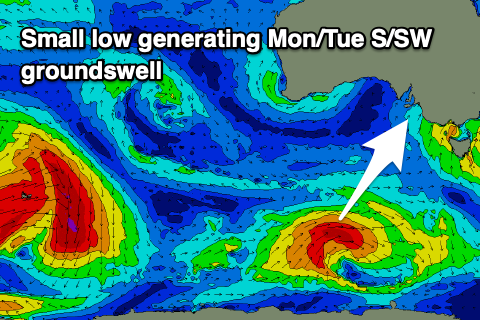 The source of this is a small, short-lived polar low firing up south of Western Australia today, generating a tight fetch of W/SW gales through our swell window while tracking east. While inconsistent it should kick Middleton back to 2-3ft from a smaller 2ft in the morning but not impact the Mid Coast.
Winds unfortunately look a little funky now as a trough deepens to our east and west, bringing strengthening S/SE winds that might be lighter and more E'ly at dawn. Strong E'ly winds then look to persist on Tuesday, feeding into a deepening mid-latitude low to our west, creating average conditions with a mix of easing S/SW groundswell and S/SE windswell.
Come Wednesday winds look a touch more favourable but still strong from the NE and with little amounts of swell.
Longer term there's nothing significant for the end of the week, while we may see a distant, but fun sized W/SW groundswell for next weekend. The models are still swapping and changing re this so check back Monday for an update. In the meantime have a great weekend!