Tons of windy swell for the Mid, with one day standing out

South Australian Surf Forecast by Craig Brokensha (issued Friday July 23rd)
Best Days: South Coast every day, though best Thursday, Mid Coast Thursday morning, but surfable all days
Features of the Forecast (tl;dr)
- Easing W/SW groundswell tomorrow, ahead of a new W/SW groundswell into the afternoon. Strengthening N tending N/NW winds
- Building W/SW swells Wed (stormy on the Mid) with strong W/NW tending W winds
- Large W/SW groundswell for Thu with N/NE tending N/NW winds on the Mid, N/NW all day down South
- Easing W/SW groundswell Fri and Sat with strong N/NW winds on Fri, strong NW tending W/NW on Sat
- Inconsistent, moderate sized W/SW groundswell Sun with strengthening W/NW tending NW winds
Recap
The forecast for the weekend and into today has played out pretty much to script.
We saw choppy 2-3ft waves on the Mid Saturday morning, becoming larger and stormy into the afternoon and evening as a strong cold front moved through, with choppy, semi-stormy waves easing through yesterday.
The South Coast was cleaner in protected spots and 2-3ft Saturday morning ahead of a late increase in size, solid yesterday and to 4-6ft with protected spots again fairing best, cleanest from mid-late morning.
Today the surf has held around 2-3ft on the Mid Coast but with choppy conditions owing to strong cross-shore winds, great down South and clean with surf easing back to 3-4ft across Middleton.
This week and weekend (Jul 27 – Aug 1)
One down, a couple more to go.
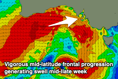
The weekend's vigorous mid-latitude frontal progression will be replicated through mid-week, with another significant mid-latitude front due to push through Wednesday.
Before this happens though we'll see the current swell easing into tomorrow morning, but a reinforcing W/SW groundswell is due into the afternoon, generated by pre-frontal W/NW gales south-west of Western Australia on the weekend.
 Middleton should drop back to 2-3ft tomorrow morning, but increase to a more consistent 3ft+ into the afternoon, with the Mid holding at 2ft to occasionally 3ft into the afternoon, smaller early.
Winds will strengthen from the N'th, shifting N/NW into the afternoon favouring the South Coast while we'll see strong W/NW tending W winds on Wednesday as the mid-latitude front pushes through.
Now, compared to Saturday's front, this won't be quite as strong with less wind locally on the coast but the swell will still be large, with severe-gale W/SW winds due to fire up south-west of Western Australia tomorrow, projecting into us Wednesday while weakening slightly.
We'll see Wednesday mostly consisting of building, mid-period W/SW swell with the groundswell peaking through Thursday.
The Mid should offer semi-stormy 3-4ft waves on Wednesday with those strong W winds, with the groundswell keeping 3-4ft sets hitting the swell magnets Thursday as winds back off and tend N/NE through the morning, N/NW into the afternoon. While not great and still bumpy, there should be some good options on the Mid Thursday for experienced surfers.
The South Coast looks to be 3ft+ Wednesday morning before building to 4-5ft later in the day across the Middleton stretch. Thursday should come in at a stronger 4-6ft and with great, moderate to fresh N/NW offshore winds.
 Into Friday we'll see stronger N/NW winds kick in along with easing surf across both coasts, best down South and dropping from 3-4ft across Middleton.
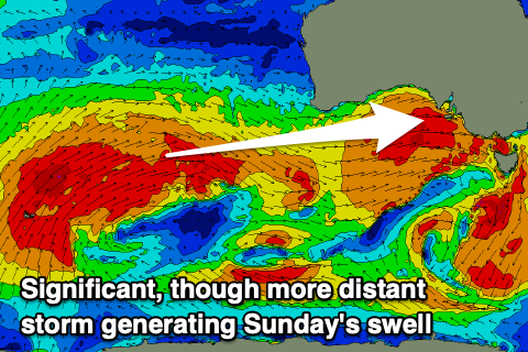
Saturday morning will start smaller again as winds shift from the NW to W/NW as a weak mid-latitude front approaches from the west. This front will be attached to a much more significant, broader frontal progression, with a polar low pushing up and into Western Australia later this week.
An inconsistent but strong, long-period W/SW groundswell is due from the polar low, arriving overnight Saturday and peaking Sunday with good 3-4ft+ sets due across Middleton, 2-3ft on the Mid Coast. Winds looks to strengthen from the W/NW tending NW on Sunday as Saturday's approaching front slides through, cleaner Monday with strong NW winds ahead of a change Tuesday. More on all of this Wednesday.