Strong frontal activity with multiple stormy days on the Mid

South Australian Surf Forecast by Craig Brokensha (issued Friday July 23rd)
Best Days: Mid Coast stormy spots later tomorrow and Sunday morning, similar Wednesday, South Coast protected spots all period though best Monday and Tuesday
Features of the Forecast (tl;dr)
- Mid period SW swell for tomorrow morning down South with strengthening W/NW winds
- Stormy W'ly swell developing on the Mid Coast into tomorrow PM, building late down South
- Stormy W'ly swell easing Sun with fresh/strong W/SW winds, tending W/NW and strengthening into the PM (W/NW all day down South)
- Fun W/SW groundswell Mon with fresh and gusty N/NW winds, smaller Tue with strengthening N'ly tending N/NW winds
- Stormy W swell developing Wed with strong W tending W/SW winds
Recap
Fun, clean waves across spots that like a touch of east in the wind on the South Coast yesterday with sets to 2-3ft across Middleton, similar in size today with a straighter, northerly breeze. The Mid Coast was tiny and bumpy yesterday with a N'ly windswell, cleaner but micro today.
This weekend and next week (Jul 24 - 30)
We should see Middleton maintaining 2-3ft waves tomorrow morning as our steady supply of background SW swell persists but winds will become an issue, strengthening from the W/NW through the day, possibly NW at periods through the morning.
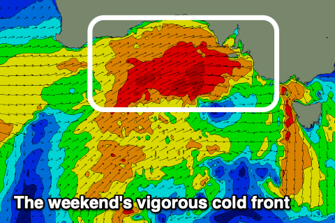
This strengthening breeze will be associated with a vigorous cold front pushing across us, and it'll whip up a stormy increase in windswell on the Mid Coast, kicking to 4ft through the late afternoon.
 The South Coast will likely see some late size building, with sets to 3-4ft from Day St, further east but choppy with those winds.
The front will move through Saturday evening with the swell due to be quite large on the Mid Coast in the darkness, easing slowly Sunday as the front slowly clears to the east.
We'll see strong W/SW winds on the Mid, swinging back to the W/NW through the afternoon with the next approaching front, while the South Coast looks to see fresh and gusty W/NW tending stronger W/NW winds.
The Mid should be in the stormy 3-5ft range Sunday morning, easing through the day, while the South Coast will be around 4-6ft across the Middleton stretch, smaller in more protected locations owing to the westerly direction.
Monday looks great down South for those in the region with fresh and gusty N/NW winds along with plenty of reinforcing W/SW groundswell energy maintaining 3-4ft waves across Middleton, with the odd bigger one towards Goolwa. The Mid will be choppy though persisting around 2-3ft.
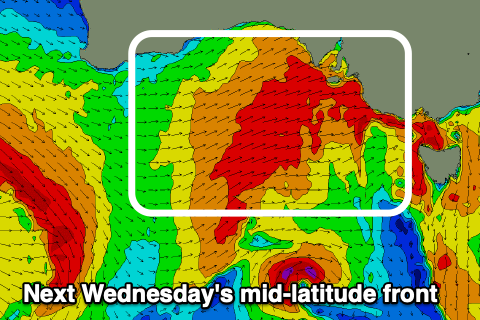 Come Tuesday the surf looks to ease just a touch though halted by a reinforcing W/SW groundswell with 3ft+ surf across Middleton, with choppy 2ft to occasionally 3ft waves on the Mid Coast as a strengthening N'ly kicks in ahead of our next, vigorous mid-latitude front.
Wednesday's front looks a touch weaker than this weekend's but we'll still see stormy surf developing through the day, hitting 3ft+ with strong W tending W/SW winds, while the South Coast looks to build to the 4ft+ range. Morning winds look favourable and W/NW, but shifting W/SW into the afternoon.
We'll see the swell easing in size Thursday and Friday as winds tip back to the NW, then stronger N/NW ahead of the next frontal system, but we'll look at this in more detail on Monday. Have a great weekend!
Comments
Should be able to get a stormy surf at Brighton jetty. At least i can walk there and well within the 2.5km lockdown rule!