Clean, very small weekend, better swells next week

South Australian Surf Forecast by Craig Brokensha (issued Friday June 11th)
Best Days: Swell magnets tomorrow morning down South, late Tuesday both coasts, Wednesday morning Mid Coast, all day down South, early Thursday South Coast
Features of the Forecast (tl;dr)
- Cleaner conditions over the weekend but with a small-tiny, fading swell
- Inconsistent W/SW groundswell building late Tue, peaking Wed AM with moderate NE tending variable winds as it builds, N/NW tending W/NW Wed
- Mid-period W'ly swell for Wed PM and Thu AM with variable tending S/SW winds
- Secondary, stronger SW groundswell Fri but with fresh S/SE winds
Recap
A continuation of poor conditions on the South Coast yesterday with a sizey S'ly windswell, but this eased as winds eased into the late afternoon, smaller again today but with a lingering onshore breeze. The Mid Coast was 1ft to occasionally 2ft yesterday morning with bumpy conditions under a cross-shore wind, back to a tiny 0.5-1ft this morning but clean.
This weekend and next (Jun 12 - 18)
Down, down, down.
The surf will continue to ease in size through the weekend, becoming tiny into Sunday and remaining so through early next week owing to the blocking effect of a broad, stalling low to our east and high to our west.
Winds will improve tomorrow as the high pushes east, bringing N/NW-N tending variable winds. An inconsistent, background SW swell is due to ease from 1-2ft across Middleton, tiny on the Mid with tiny 1ft waves left across Middleton Sunday and Monday, possibly flat Tuesday morning.
Winds will remain favourable and offshore from the N in the morning Sunday, tending E through the afternoon and N/NE tending variable Monday.
Of greater importance is the new, inconsistent W/SW groundswell due late Tuesday, peaking Wednesday morning.
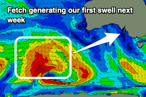 This will be generated by a distant frontal progression that's currently north of the Heard Island region.
A great fetch of strong to gale-force W'ly winds are being aimed through our western swell window, with a secondary intensification of W/SW gales due to fire up south-west of Western Australia this afternoon and evening, breaking down tomorrow.
A fun though inconsistent W/SW groundswell will be generated, arriving Tuesday afternoon and possibly kicking the Mid Coast tot 1-1.5ft by dark, coming in at a better 1-2ft on Wednesday. The South Coast should see fun 3ft sets across Middleton at the swells peak Wednesday along with N/NW tending W/NW winds. The Mid will likely see early N/NE winds but quickly swing onshore.
An additional pulse of new W'ly swell is due for the Mid into Wednesday afternoon and Thursday morning as a mid-latitide front initially projects a fetch of strong to gale-force W/SW winds up and under Western Australia Sunday and Monday. Sets to a good, consistent 2ft are due and with those workable winds.
The swell will ease through Thursday and a trough looks to bring early light winds before shifting S/SW through the morning.
Longer term, a polar low forming around Heard Island on Sunday evening will generate a pre-frontal fetch of W/NW gales, giving way to stronger severe-gale to storm-force W/SW winds, south-west of Western Australia, then weakening once moving under the country.
This should generate a moderate-large, long-period SW groundswell for Friday, building to 3-5ft down South and to 1-1.5ft on the Mid Coast but with fresh S/SE winds in the wake of Thursday's change. More on this in Monday update though. Have a great weekend!
Comments
Do u think it will be westerly on the eyre from Monday or still have some North?
Depends where you are, southern half NNE, top no, W/NW tending SW.