Clean run for the South Coast, a fun day on the Mid

South Australian Surf Forecast by Craig Brokensha (issued Friday May 28th)
Best Days: South Coast every day from tomorrow through Wednesday, Mid Coast Sunday
Features of the Forecast (tl;dr)
- Mid-period S/SW swell for today, easing Sat with NE tending E/NE winds
- New moderate sized W/SW groundswell filling in Sun with fresh E/NE tending N/NE and then variable N/NW winds on the Mid, fresh N/NE tending variable down South
- Easing W/SW groundswell Mon with fresh N/NE tending variable winds
- Inconsistent SW groundswell for Wed PM with N/NE tending NW winds, easing Thu with S/SW winds
Recap
A window of clean conditions across both coasts yesterday morning but the swell was a bit weak and mixed, easing from 1-2ft on the Mid Coast and 3ft off Middleton.
Today the surf is cleaner but tiny on the Mid Coast, lumpy down South with a light to moderate onshore breeze and weak 3ft sets across the Middleton stretch.
This weekend and next week (May 29 – Jun 4)
The weekend is looking much better for a wave across the South Coast as winds swing offshore from the NE tomorrow morning, along with 2-3ft of mid-period S/SW swell across Middleton.
This swell was generated by a weak front moving through our swell window yesterday, with it arriving this afternoon, easing through tomorrow. The Mid Coast will also be clean but tiny.
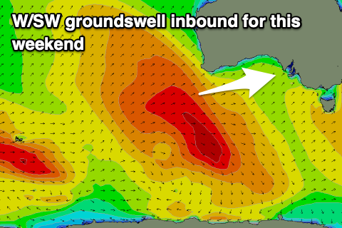 Into Sunday our new, inconsistent W/SW groundswell should fill in, generated by the slow moving mid-latitude low through the southern Indian Ocean this week. The low is now breaking down south-west of Western Australia.
A fetch of persistent W'ly gales have been generated through our western swell window, producing a good swell that should increase to 2ft on the Mid Coast across most breaks but the regional swell magnets should hit 3ft on the favourable parts of the tide.
The South Coast should build to 3ft off Middleton through the day with 4ft sets at Goolwa, a little undersized early.
Winds look favourable for both coasts with a moderate to fresh E/NE breeze on the Mid, shifting more N/NE and then easing from the N/NW into the afternoon, N/NE tending variable down South.
Winds will have a bit more north to them on Monday, moderate to fresh N/NE tending variable on the Mid and similar down South as the swell eases back from 2ft on the Mid Coast and 3ft on the sets off Middleton.
Into Tuesday and Wednesday will see winds persist out of the north as a mid-latitude low forms off the southern Western Australian coast, moves slowly east into the Bight while weakening.
The surf will continue to ease in size though, tiny on the Mid Tuesday and fading from 2ft across Middleton with a moderate N/NE tending N/NW breeze, variable into the afternoon.
Wednesday morning will start tiny with a moderate to fresh N/NE tending NW breeze, but a new, inconsistent SW groundswell is expected into the afternoon.
The source of this swell will be a short-lived polar front firing up east of Heard Island this afternoon, generating a burst of W/SW gales before weakening through tomorrow.
The swell should kick to an inconsistent 2ft to possibly 3ft across Middleton Wednesday afternoon, tiny on the Mid Coast, easing Thursday from a similar size but with a S/SW change as the remnants of the low finally push east.
Longer term we'll see the Southern Ocean start to fire up but the frontal activity looks to be less than favourable initially with W/NW-NW fetches pushing east-southeast across our swell window. Some better aimed and projecting action may be seen into the following week, but more n this next week. Have a great weekend!