Strong swell for tomorrow but with lots of wind, similar Wednesday

South Australian Surf Forecast by Craig Brokensha (issued Friday May 21st)
Best Days: Protected spots tomorrow and Wednesday morning for the keen down South, Thursday both coasts, Friday morning South Coast, Saturday morning South Coast, Sunday and Monday both coasts
Features of the Forecast (tl;dr)
- Mod-large W/SW groundswell for tomorrow, peaking from late morning but with strong N/NW tending NW and then W/NW winds
- Easing mix of windswell and groundswell Wed with strong though abating W/SW-SW winds
- Cleaner waves across both coasts Thu with a further drop in size
- Mid-period S/SW swell Fri AM, easing into the PM and Sat with variable S/SW winds on the South Coast, E/SE on the Mid
- New moderate sized W/SW groundswell building Sun with NE tending E/NE winds
Recap
Friday's fun pulse of swell with the tide eased back in size on Saturday across the Mid with clean 1-1.5ft sets, while the South Coast was a great 3ft with light offshore winds. Sunday saw a little less size to start with across both coasts and our new pulse of W/SW swell didn't look to perform well at all with the Mid Coast remaining tiny.
Today a tiny 1ft wave is continuing across the Mid Coast with the South Coast bottoming out, dropping to a tiny 1-1.5ft.
This week and weekend (May 25 - 30)
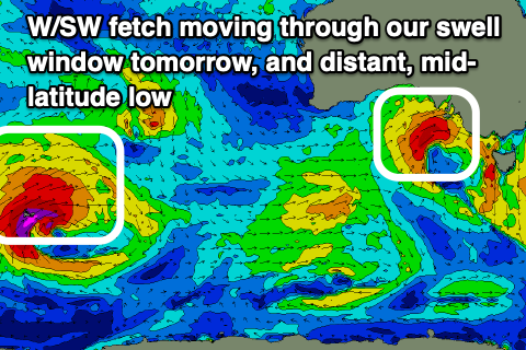
With the swell bottoming out today, it'll only be temporary with a strong new W/SW-SW groundswell due to fill in tomorrow but with strong and tricky winds. The swell was generated by a strong polar low firing up around the Heard Island region late last week, projecting storm-force W/SW winds towards us, weakening while heading up more towards Western Australia.
The remnants of this storm have now formed into a mid-latitude low and this is moving in from the west, bringing strong N/NW tending NW winds tomorrow morning, shifting W/NW through the afternoon.
This will bring a building windswell along with the groundswell proper with the Mid Coast due to build to 3ft+ through the afternoon with 4-5ft waves across Middleton and the odd bigger one from Day St further east. It'll be inconsistent at times and with those winds, tricky and best in protected spots.
 The backside of the low will project a fetch of strong to gale-force W/SW winds into us and unfortunately this will see winds blow strong from the W/SW across the South Coast into Wednesday morning, SW on the Mid Coast with similar sized surf to Tuesday afternoon, easing through the day.
Thursday looks better with light W/NW breezes due down South, S/SE on the Mid Coast through the morning with the swell easing from 2ft, and the 3-4ft range across Middleton.
A reinforcing pulse of mid-period S/SW swell should be seen later Thursday but more so Friday, generated by a weak, trailing fetch of strong SW winds moving through our swell window Wednesday.
Size wise, Middleton looks to hold around 3ft, easing Friday afternoon and smaller Saturday. The Mid will become tiny into Friday.
Winds are a touch dicey for the South Coast but might be variable in the morning, otherwise S/SW, with E/SE winds on the Mid. Cleaner conditions are likely Saturday with a NE breeze as the surf eases.
Moving into Sunday and an inconsistent but good W/SW groundswell is due to fill in, generated by a strong mid-latitude firing up north-east of the Heard Island region, tracking slowly east while generating a fetch of W/SW gales from tomorrow through Thursday evening.
A healthy sized swell is due with it arriving overnight Saturday and building Sunday, reaching 2-3ft on the Mid Coast and 3ft to possibly 4ft across the Middleton stretch. Winds look nice and locally offshore in the mornings, but more on this Wednesday.