Stacks of swell, gotta pick the winds

South Australian Surf Forecast by Ben Matson (issued Wednesday 12th May)
Features of the Forecast (tl;dr)
- Windy conditions both coasts Thurs/Fri, persisting Sat at Victor
- Solid swells building Thurs PM, becoming large Fri/Sat, easing Sun
- Mid Coast looking good Sat with lighter winds and easing swells
- Another large swell Mon for Victor, with light winds, easing Tues
- Strong surf due next Fri/Sat with light winds
Recap
Tuesday delivered fun small waves on the Mid with light winds and reasonable 2ft sets. Victor remained solid but poor with onshore winds. Today we’ve seen an easing of both wind and swell, and a steady improvement in conditions across the South Coast whilst the Mid’s remained clean with inconsistent 1-2ft sets. Wave heights have eased along the South Coast from 3-4ft to 2-3ft.
This week (May 13 - 14)
*Today’s Forecaster Notes will be brief as Craig is away*
We’re at the cusp of a spell of windy conditions as an amplifying Long Wave Trough steers a succession of vigorous cold fronts into the South Australian coastline.
The first front is due mid-morning Thursday, swinging freshening NW winds to the SW. A second cold front will arrive a few hours before dawn on Friday, renewing strong SW winds across all coasts, ahead of a third front due Friday evening.
This means that, apart from a few hours of early NW winds on Thursday morning, we’re looking at choppy conditions at Victor both days. Winds will ease overnight and revert back to the NW ahead of the second front but this will largely occur under the cover of darkness; Friday will remain blustery with SW winds. There will however be no shortage of size by Friday, with initially small waves Thursday morning increase into the afternoon ahead of wind affected 4-6ft surf by late Friday.
As for the Mid Coast, both days will be similarly bumpy as per Victor but we should see plenty of swell, thanks to an active storm track over the last few days riding high in the Bight, allowing for a reasonable percentage of west in the swell direction. This should build wave heights to a bumpy 2-3ft+ by Thursday afternoon and early Friday, reaching 3-4ft into Friday afternoon as a stronger pulse from a better, more vigorous secondary fetch.
There probably won’t be quite enough wind (and swell) for a proper metro stormy though, just a few small sloppy windwaves if you can’t get down to the Mid.
This weekend (May 15 - 16)
Down South, Saturday looks to be post-frontal in the wake of Friday night’s change, whilst Sunday morning will see generally light variable winds as another front approaches from the south, bringing moderate W/SW winds into the afternoon.
As such, Saturday looks average at Victor though there’ll be plenty of size, with 5-6ft sets at Middleton as the broader swell trend reaches a peak. Size will ease from 4-5ft to 3ft during Sunday, and this this will be your best time to surf.
On the Mid Coast, we’ll see very little wind all weekend. The synoptic flow should be light enough early Saturday to steer the breeze to the SE though moderate southerlies are possible during the day. Easing swells from Friday should still manage 2-3ft sets, abating to an inconsistent 2ft on Sunday as winds remain light.
Next week (May 17 onwards)
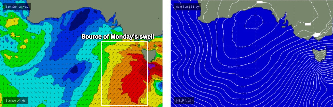
Sunday’s late approaching front will undergo intensification below South Australia (see below), which means the swell direction will be quite southerly - fine for Victor but bad news for the Mid. So, expect small residual swell in the gulf while the South Coast rebuilds back into the 4-6ft range at Middleton with bigger surf at the swell magnets reefs.
Even better, the front will have quickly cleared to the east, allowing conditions to improve quickly. So, it’s looking like a good start to the week down south.
Wave heights will then slowly ease from Tuesday (4-5ft down to 3-4ft) with similarly favourable conditions holding into Wednesday as we head towards a low point in surf size (3ft easing to 2ft), persisting into Thursday.
A strong zonal frontal progression south of WA early next week looks like setting up an excellent W/SW groundswell for Friday and Saturday, and fortunately the storm track looks like it’ll be steered well to the south of the state so this next event should be accompanies by lighter winds. More on this in Friday’s update.