Stacks of surf ahead, just gotta pick the winds

South Australian Surf Forecast by Ben Matson (issued Monday 3rd May)
Features of the Forecast (tl;dr)
- Plenty of solid groundswell all week
- Poor winds for the South Coast for the next few days, Thursday and Friday the pick of the working week
- Small waves on the Mid all week, biggest early Tues, then later Thurs/Fri
- Good weekend of waves with a solid groundswell peaking Sunday
- Strong surf next week though more likely to become wind affected
Recap
The weekend delivered very small surf, with residual lines on the Mid Coast both days and very little action at Victor thanks to tiny surf Saturday and an afternoon onshore change on Sunday. Today’s delivered poor conditions at Victor though with a building swell, and small onshore building surf in the gulf.
This week (May 4 - 7)
*Today’s Forecaster Notes will be brief as Craig is away*
Recapping Craig’s expectations for the new swell due later today, and the Cape du Couedic buoy has recorded an impressive J-curve in swell periods and wave heights since about late morning. The spectral trace shows that most of the current energy is in the 18 second range (following the swell front at 20 seconds), with a secondary swell at about 13-14 seconds.
So, it’s mainly groundswell with only a small southerly windswell in the mix. This is different to the Cape Sorell buoy off Tasmania’s West Coast, which has a larger percentage of southerly windswell at the moment.
All that taken into account, and also confirming visually the size of the (same) swell that reached Margaret River yesterday for the WSL with 12ft+ sets on offer at most reefs (bigger at offshore bombies), and I can’t really see any need to adjust Craig’s estimate for a peak around 6-8ft at Victor overnight tonight, easing from 5-6ft tomorrow. Unfortunately, a developing low pressure centre in eastern Bass Strait and a high south of the Bight will maintain moderate to fresh S’ly winds at Victor on Tuesday, so conditions won’t be great.
Surf size will ease back to 3-5ft on Wednesday, and conditions will slowly improve as winds become light E’ly - though there may be some leftover wobble, especially in the morning.
An active frontal passage through the Southern Ocean all week should maintain 3-4ft surf at Middleton on Thursday and Friday (bigger at the swell magnets), with the odd bigger bombs possible late Thurs and early Friday, thanks to the arrival of one particularly nice long period pulse, originating from a powerful storm near Heard Island yesterday that should also ramp in the consistency a little. Conditions look to be pretty good under a light N’ly breeze, so either day is worthy of some flexi-time.
As for the Mid Coast, conditions look pretty good all week with tomorrow’s S’ly synoptic flow likely to be steered into an early S/SE, maybe SE breeze, along with 2ft+ of easing surf. The afternoon may become a little bumpy as the breeze shifts back to the south though.
We’ll see smaller waves into Wednesday and Thursday morning, though most of the reefs should pick up fun 1-2ft+ waves on the more favourable parts of the tide.
Late Thursday and Friday are Friday are also on track for a slightly bigger pulse from the aforementioned storm, though Thursday afternoon is at risk of a freshening northerly as a cold front slips to the south. Both days have the potential for occasional sets in the 2ft to almost 3ft range on the Mid Coast, though as per usual with long range swell sources, we can expect long breaks between the bigger sets.
This weekend (May 8 - 9)
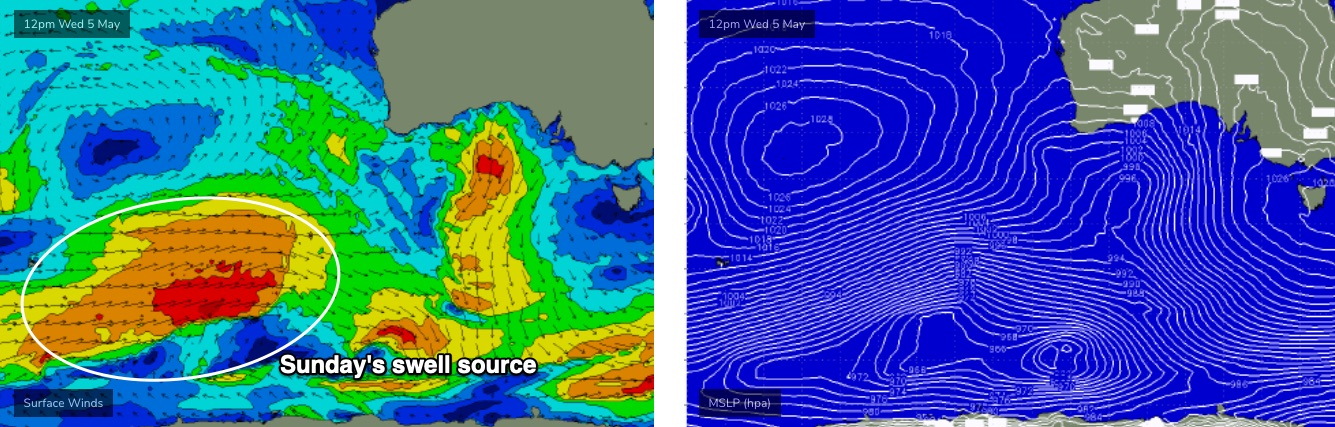
Early indications are for another strong long period groundswell to arrive this weekend - peaking Sunday - originating from the tail end of the current storm sequence in the Southern Indian Ocean, between Madagascar and Heard Island.
It’s expected to maintain strength as it passes through our far and mid-range swell windows over the coming days (see image below from Wednesday), and following a temporary easing trend on Saturday, should rebuild on Sunday into the 4-6ft range across the Middleton stretch, with bigger sets at the swell magnets (don’t be surprised for the odd 6-8ft bomb).
The Mid Coast should do well from this well event, increasing to 2-3ft+ on Sunday (smaller leftover surf on Saturday). I’m a little concerned that the swell direction may be a smidge to south for the gulf, but what’s working in its favour is the active storm track ahead of the main swell generating system. It’s these kinds of extended periods of activity that usually tips the balance in favour of the Mid producing decent waves.
As for conditions, a weak frontal passage may create moderate S/SW winds at some point - probably Saturday - but Sunday’s shaping up with light winds all ‘round. Well worth considering for a surf.
I'll firm up the timing and size specifics on Wednesday and Friday.
Next week (May 10 onwards)
There's no sign of any letup of the Southern Ocean storm track for the long term, though we may see less favourable conditions as it pushes closer to the mainland and thus has a more direct influence on our local winds.
So, the first half of next week is on track for large, but windier surf throughout the South Coast and plenty of action in the gulf too. More on this in Wednesday’s update.