Flag the coming days, surf the period afterwards

South Australian Forecast by Craig Brokensha (issued Wednesday 9th December)
Best Days: South Coast Saturday morning, Sunday, Monday
Recap
The Mid Coast cleaned up a bit yesterday morning but remained bumpy and average with cross-shore winds and weak, easing 2ft sets. The South Coast remained onshore but with reduced strength and workable, solid sets to 4ft+ across Middleton.
Today is much better across all locations with a reinforcing S'ly swell maintaining 3ft+ waves across Middleton with an offshore wind, clean on the Mid though tiny and to 1-1.5ft.
This week and next (Dec 10 - 18)
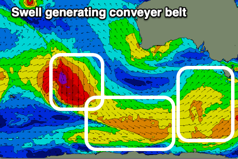
Today's good S'ly swell seen across the South Coast will fade in size through the end of the week, while a strong high moving in slowly from the east will bring poor and strong SE tending S/SE winds tomorrow and E/SE tending S/SE winds Friday.
These strong winds will kick up some junky S/SE windswell to 3ft or so, but there'll also be some new mid-period S/SW swell in the mix from a broad polar front that's currently projecting towards Tasmania, peaking Friday.
This will be the first of three systems skirting around the southern and south-eastern flank of the high moving in from the west, just within our southern swell window.
The size of the mid-period S/SW swell looks to be 3ft+ or so across the Middleton stretch Friday but with those poor E/SE-S/SE winds and the Mid Coast will be tiny to flat with the southerly swell direction.
 Moving into the weekend, conditions will improve slowly as the high continues east, swinging winds E/NE-NE on Saturday morning and N/NE Sunday ahead of mid-afternoon sea breezes.
Swell wise, Friday's mix of swells will ease from a peaky 3ft, and a reinforcing mid-period S/SW swell from a second polar front generating strong W'ly winds along the shelf will slow this easing trend.
We'll likely see a low point in swell Sunday morning to 2ft on the sets across Middleton with those cleaner conditions, while into the afternoon a new S/SW groundswell should fill in.
This third swell will be generated by the third storm firing up through our swell window, that being a strong low tracking south-east from the southern Indian Ocean, moving along our Great Circle Path while generating a fetch of severe-gale NW winds.
It'll weaken on the polar shelf as winds swing more W/NW, with the long-period energy due to travel up and into us Sunday afternoon, peaking overnight and then easing Monday. While not ideally aimed towards us, we should still see Middleton kick to 3ft on the sets later Sunday, easing from 2-3ft on Monday morning. The Mid Coast will remain tiny to flat.
Winds will remain favourable and offshore Monday out of the N/NE, with a S'ly change moving through Tuesday. This change and another strong high will lead to a poor run of S'ly winds and no real groundswell energy, but more on this Friday.