Another strong swell due late week

South Australian Forecast by Craig Brokensha (issued Monday 23rd November)
Best Days: South Coast magnets Wednesday until mid-afternoon, Mid Coast Thursday afternoon, both coasts Friday, South Coast Saturday morning
Recap
The swell seen late week dropped away through the weekend but conditions improved down South with fun surf across the swell magnets Saturday morning, tiny Sunday.
The Mid Coast's fun waves from Friday dropped right back overnight leaving tiny waves for beginners Saturday, tiny Sunday morning ahead of a new kick in small W/SW swell through the afternoon.
Today the surf is tiny and wind affected on the Mid, poor and onshore down South with no size.
This week and weekend (Nov 24 - 29)
After a few days of average surf, we've got a much better outlook from the middle of this week, with a large W/SW-SW groundswell on the cards for Thursday/Friday.
Ahead of this though, tomorrow will be a lay day with today's small to tiny W/SW swell due to drop further in size along with a light onshore breeze down South, SE on the Mid but with no size.
Wednesday should be fun across exposed breaks with a small pulse of mid-period S/SW swell, generated by a late forming low in our swell window. This low generated a fetch of strong to gale-force W/SW winds in our swell window yesterday afternoon through this morning.
Size wise Middleton is only expected to offer 2ft waves (possibly the rare bigger one) with 3ft surf across more exposed breaks. The Mid will be tiny to flat. Winds look favourable and offshore from the N/NE, swinging W/NW early afternoon ahead of late afternoon sea breezes.
We then look at the larger, stronger W/SW groundswell due into the end of the week again.
There are a few similarities to last week's system, but also a few differences.
The low won't 'bomb' like last week's but it'll deepen and form within a trough drifting south-east from the Indian Ocean, strengthening south-west of WA and in a more southerly position, initially in our west-southwest swell window, moving more into our south-western window. It'll also project with strength under us, producing a more consistent, larger swell event, with a touch less period (though still strong).
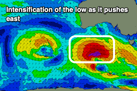
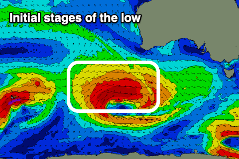 An initial fetch of W/SW gales are forecast to be projected towards us, with a secondary intensification of severe-gales generated in our south-western swell window on Tuesday evening and Wednesday morning, on top an active sea state. This will help create a large, strong pulse of swell Thursday afternoon.
The swell is due to arrive mid-morning Thursday, building rapidly into the afternoon and reaching 5-6ft across Middleton, with bigger sets on the deep water reefs and more exposed beaches, while the Mid Coast should build to a consistent 2-3ft.
 The swell will ease Friday from a more SW direction with 2ft sets likely most of the day on the Mid, tiny Saturday while the South Coast should ease back from 4-5ft Friday morning, down further 2-3ft Saturday morning.
Looking at the local winds and a trough moving through Wednesday evening will clear quickly to the east resulting in winds swinging back to the SE Thursday, fresh and only tending S/SE into the afternoon. This will create great conditions as the swell kicks on the Mid.
The South Coast will be better come Friday with winds swinging light N/NE ahead of afternoon sea breezes with a NE tending NW breeze on the Mid Coast, with SW sea breezes.
On the weekend, variable tending light offshore winds are due Saturday with the easing swell, while a strong high moving in Sunday looks to bring strong S/SE winds as the swell reaches a low point.
Longer term a slow moving, strong polar low is due to form on the weekend, south-southwest of WA, possibly generating a moderate sized SW groundswell for early-mid next week, but winds look to persist out of the south, more on this Wednesday.