Good run of westerly swell with favourable winds

South Australian Forecast by Craig Brokensha (issued Wednesday 30th September)
Best Days: Both coasts tomorrow, South Coast Friday and Saturday, possibly Saturday afternoon on the Mid, Sunday on the Mid
Recap
Fun, clean leftover S'ly sets yesterday from Middleton to Parsons on the right board, tiny today and only for beginners. The Mid Coast has been flat and wind affected.
This week and weekend (Oct 1 - 4)
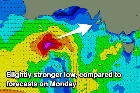 We've got an upgrade in the swell due from the current mid-latitude low that's south of the Bight and tracking east-southeast. A good, tight fetch of gales is being generated through our western and south-western swell windows, with even core wind speeds up to severe-gale being registered.
This swell will fill in tomorrow and peak through the afternoon with Middleton now expected to reach 3ft+ across the Middleton stretch while the Mid Coast should kick to 2ft+.
Winds look great and favourable for both coasts, N/NW down South all day, with the Mid Coast seeing variable NE tending N'ly winds, back NE later in the day.
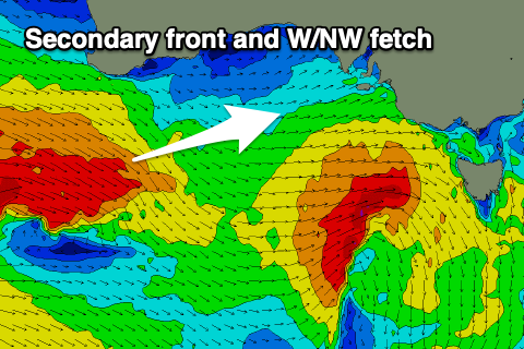
The secondary reinforcing pulse of W/SW groundswell is also on track for Friday afternoon, generated by a secondary mid-latitude front moving in this evening and tomorrow, producing a good fetch of W/NW gales under WA and south of the Bight.
 We'll likely see Thursday afternoon's swell drop back to 3ft across Middleton and 2ft on the Mid Friday morning, with the W/SW groundswell keeping similar sized sets hitting both regions into the afternoon, then easing Saturday from 3ft and 1-2ft respectively.
Winds will strengthen though as a deepening surface trough slowly moves in from the west, bringing gusty N/NE winds holding most of the day on the Mid Coast, and strong N/NW down South.
Come Saturday the trough will near closer with stronger and tricky N/NW winds, possibly tending variable into the afternoon as the trough lines pushes further east. Following this we may see a late S'ly change, and this will persist into Sunday with strong S'ly winds and a final pulse of reinforcing W/SW groundswell.
This will be generated by a more distant fetch of strong to gale-force SW-W/SW winds developing south-west of WA this afternoon and evening. The fetch will almost be anchored in positioned, weakening through tomorrow evening, with an inconsistent W/SW groundswell spreading out and arriving across our region on Sunday.
The Mid Coast should see fun, inconsistent 2ft sets across the swell magnets, with Middleton persisting around 3ft+ but with those poor winds.
Moving into next week, it looks like winds will persist out of the south to south-east Monday and Tuesday as the swell eases, with a reinforcing S/SW groundswell mid-week as winds possibly improve. More on this Friday though.