Windy and sizey waves to continue on the Mid, southerly swells for the South Coast

South Australian Forecast by Craig Brokensha (issued Monday 19th August)
Best Days: Protected spots South Coast later tomorrow and more so Friday, Mid Coast Sunday morning, South Coast Monday
Recap
Tiny surf on the South Coast yesterday with strengthening winds, poor and with a building NW windswell on the Mid Coast.
Today winds are stronger onshore across the Mid with an increase in size, clean but tiny down South. We also saw a good drenching of rain as the mid-latitude low pushed across us last night.
This week and weekend (Aug 20 - 23)
A strong mid-latitude low is currently pushing across us, with the swell generating fetch riding high in the Bight, leading to the lack of size across the South Coast. Kangaroo Island is blocking all this westerly energy coming in.
The low will continue east this evening, dragging up a polar front behind it and with this we'll see the size starting to build across the South Coast from tomorrow.
Most of the energy will be weak and windswelly, especially tomorrow, with a better mid-period S/SW increase due into Friday afternoon.
 This will be generated by a strong fetch of SW winds being projected up towards us from this afternoon through tomorrow.
Ahead of this swell though we'll see local SW-W/SW winds generating a poor quality SW swell tomorrow to 2ft+ or so across Middleton, likely reaching 3ft into the afternoon. The Mid Coast will persist around 2-3ft, likely more consistent in that upper range into the afternoon as onshore winds strengthen from the W. The South Coast should remain OK in protected spots with winds holding out of the W-W/NW.
Friday will see strong W/SW winds across both coasts all day (possibly more W'ly around Victor early) along with 3ft of semi-stormy swell on the Mid Coast and increasing size down South from 3-4ft in the morning to 4-5ft+ into the afternoon.
Try protected spots down South for the best surf.
As we move into the weekend, the progression as a whole will start moving east, swinging winds SW into Saturday and remaining strong, with moderate to fresh and easing S/SE breezes on Sunday.
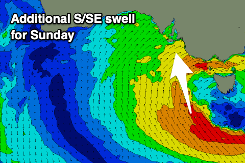 Unfortunately the swell will ease rapidly out of the W/SW on Saturday across the Mid, dropping from 2-3ft and only likely being an inconsistent 1-2ft on Sunday while cleaning up. The South Coast will remain sizey all weekend with the easing mid-period S/SW swell Saturday from 4-5ft+, but our additional S/SE groundswell for Sunday is still on track.
This will be generated by a great fetch of strong to near gale-force S/SE winds wrapping around the southern flank of the progression, with it keeping the South Coast up around an easy 4-5ft on Sunday morning, easing into the afternoon and then down from 3ft Monday.
Monday still looks the pick for the South Coast as winds shift back to the N/NE, but get in early for the most size.
Longer term a strong high will move in from the west keeping a lid on any major swell production, but an elongated polar frontal progression moving in from the Heard Island region may generate small pulses of SW swell. More on this Friday.
Comments
Looks like the offshores for Sunday down south (as per the previous forecast) have now evaporated., just like the hopes and dreams of local surfers...
Yep, owing to the progression as a whole stalling a bit longer than forecast Monday.
My balloon definitely just burst. Dammit Craig, you're letting the team down!