Endless westerly swells with light winds

South Australian Forecast by Craig Brokensha (issued Monday 27th July)
Best Days: Every day this period for the South Coast, Mid Coast for the keen tomorrow, but more so Thursday and Friday
Recap
A fun, clean 1-2ft of W/SW swell on Saturday coming in a little above the expected 1-1.5ft, fun also down South on the swell magnets with clean 2ft sets across Middleton.
Sunday held around a similar size on the Mid Coast with the South Coast a touch smaller but nice and clean with variable winds into the afternoon.
Today conditions were average across both coasts, small and onshore down South and cleaner though still wind affected on the Mid with a building W/SW swell to 1-1.5ft.
This week and weekend (Jul 28 - Aug 2)
After today's swing in winds to the S/SE we'll see conditions improve across all locations tomorrow as a high moves in from the west along with a new SW groundswell.
The SW groundswell has been generated yesterday and this morning by a strengthening fetch of W/SW gales through our south-western swell window and we should see the Mid Coast offering slightly better though inconsistent 1ft to possibly 2ft sets on the favourable parts of the tide, 3ft to occasionally 4ft off Middleton.
Light morning offshores are due (N/NE South Coast and E Mid Coast), holding into the afternoon. A slight drop in size should then be seen Wednesday with N/NW tending NW winds down South, N/NE tending N on the Mid Coast.
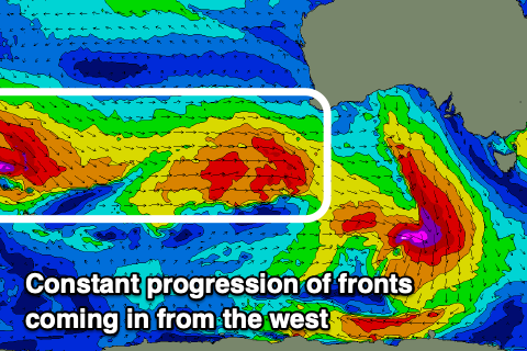 From Thursday through the weekend, various pulses of similar sized W/SW groundswell are due to impact the state, generated by back to back mid-latitude frontal systems moving through our swell window from the southern Indian Ocean, then under the country.
We're due to see the Mid Coast persisting around 2ft on the sets working the favourable parts of the tide, though Friday/Saturday look to offer better 2ft+ waves with the best pulses of swell.
Middleton should come in around 3ft+ for the most part from Thursday, with a couple of possibly slightly bigger days in the mid.
With the frontal activity weakening and sitting just a bit south of us through the period winds look favourable with local offshore winds on the cards again for Thursday morning ahead of weak sea breezes, similar Friday before we see freshening N'ly tending N/NW breezes Saturday ahead of a front.
Sunday then looks best down South with W/NW breezes, but more on this in Wednesday's update.
Longer term the final front in the progression is expected to push up and across Victoria and Tasmania early next week bringing S'ly winds to our coast and some possible new S/SW swell, cleaning up and easing Tuesday. More on this Wednesday though.
Comments
Send something special towards the boot next week Craig, if you can. I'm getting out of the rat race for a week and would love to hook into some YP juice.