Increasing swells from the west but increasing wind

South Australian Forecast by Craig Brokensha (issued Wednesday 15th July)
Best Days: Both coasts tomorrow (Mid arvo), and Friday (early Mid), South Coast Saturday and Sunday morning
Recap
Small and fun waves for beaches that like a touch of east in the wind on the South Coast yesterday, better this morning with a straighter offshore wind and straight 2ft sets off Middleton.
The Mid Coast has hung around an inconsistent 1ft with the long-range W/SW groundswell.
This week and weekend (Jul 16 - 19)
These notes will be brief as Ben's on annual leave.
Moving into tomorrow we've got the first of our better W/SW groundswells due, generated over the weekend by a strong storm projecting north-east from the Heard Island region.
The morning looks small but we should see the Mid Coast building to 2ft on the sets across the into the afternoon, easing from a similar size Friday while Middleton should see good 3ft sets.
 Winds for the South Coast now look a little dicey as a weak trough clips the region, but we'll likely see light morning N/NW winds, giving into S/SE sea breezes. So no major change to the outlook. If the trough is a touch stronger it'll bring S/SW winds at dawn.
The Mid shoud be fun with E/NE tending NE breezes and variable NW into the afternoon. Friday will be great all day down South with N/NE tending N/NW winds, bumpy though OK on the Mid with NE tending N winds.
The secondary pulse of slightly stronger W/SW groundswell for the weekend is also on track, with the storm linked to it following a similar track to the one generating tomorrow and Friday's swell.
The swell will be building through the morning and peaking into the afternoon with 3-4ft sets off Middleton, though very inconsistent and building to 2-3ft on the Mid Coast magnets.
Unfortunately winds will still strengthen from the N'th and tend N/NW-NW on the Mid creating bumpy conditions and favouring the South Coast. Sunday will be best early on the South Coast with a strong NW'ly, giving into an early afternoon W/SW change.
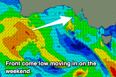
The change in winds and weather will be linked to a strong mid-latitude frontal passage come low moving in from the west. The models diverge on its track as it approaches from the west with EC having it staying a little lower but either way we'll see a stormy increase in W/SW swell for the Mid Coast Sunday afternoon, easing Monday, less so on the South Coast if the low stays north.
More on these developments Friday.