Fun week of waves for the South Coast

South Australian Forecast by Craig Brokensha (issued Monday 6th July)
Best Days: South Coast every day until Saturday afternoon (biggest tomorrow and Wed AM), Mid Coast desperate surfers Friday
Recap
Friday's mix of swells, and especially the westerly component eased back much more than expected into Saturday with tiny 1ft sets left on the Mid, with workable waves across the South Coast though back to 2-3ft.
Sunday was tiny on the Mid while the South Coast was cleaner and a fun 2-3ft with a S/SW swell in the mix.
Today a new inconsistent SW groundswell has kept waves around 2-3ft hitting the South Coast with great conditions, clean but only to 1ft or so on the Mid.
This week and weekend (Jul 7 - 12)
Today's inconsistent SW groundswell will ease tomorrow, but we've then got our fun S/SW groundswell due to take its place tomorrow and Wednesday.
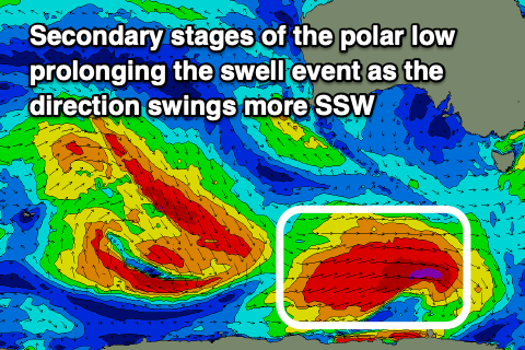 The source of this swell was a strong low forming south of WA on the weekend, with a burst of severe-gale to storm-force W/SW winds generating an initial pulse of long-period energy for tomorrow morning. The developments as the low broadened and continued to generate severe-gale W/SW winds on the polar shelf are the most promising, with this fetch moving out of our swell window this morning. This will prolong the swell event as the direction swings more southerly into Wednesday.
Looking at the expected size and Middleton should come in around 3ft+ tomorrow and Wednesday morning, easing into the afternoon with Thursday smaller and dropping from 2ft.
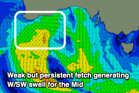
The Mid will pick up a tiny W/SW swell through this period, generated by a weak mid-latitude low that's currently off the WA coast. This will slip into our swell window tomorrow, with weak fetches persisting into Wednesday while the low moves slowly east, continuing Thursday and then moving across us Saturday.
 Size wise, tiny surf to 1ft or so is expected Thursday with possibly 1-1.5ft sets Friday through Saturday, fading Sunday.
Conditions look excellent for the South Coast through this period with N/NE tending E/NE winds tomorrow, N tending variable N/NW on Wednesday and then N'ly all day Thursday.
From Friday and into the weekend there's no new significant swell on the cards owing up an upper level ridge moving in. This will block any major swells away from us. Some infrequent background swell is due Friday and Saturday though, but don't expect anything over 1-2ft across Middleton and with long waits for sets.
Exposed breaks will be better with N/NE winds Friday, while Saturday looks best early with N'ly offshore ahead of a shallow S/SE change, fresher into Sunday.
Longer term a significant storm forming in our medium-long range swell window looks to generate a large long-period W/SW groundswell for next week, along with follow up activity. Winds also look favourable out of the north as the storms stay at arms length. More on this Wednesday though.
Comments
Tiny waves continue on the Mid..