Continuation of westerly swells as winds deteriorate

South Australian Forecast by Craig Brokensha (issued Wednesday 27th May)
Best Days: Mid Coast keen surfers tomorrow, South Coast all period besides Saturday (windy) and Monday
Recap
Tiny to flat and wind affected on the Mid Coast yesterday with northerly winds, building today and peaky again with the increasing W/SW groundswell and additional windswell peaks.
The South Coast eased from 1-2ft yesterday, while today there's some new energy with the W'ly swell with 2ft+ sets off Middleton, up to 2-3ft at Cliffs and Goolwa.
The new swell has spiked on the Cape du Couedic wave buoy and we should see the Mid Coast reaching 3ft (and possible bigger bomb) with the help of the incoming tide as winds later afternoon and into the evening, creating improving conditions. The South Coast looks to hang around 2-3ft or so.

New swell already reaching head-high
This week and weekend (May 28 - 31)
This afternoon's large spike in W'ly groundswell is expected to ease back through tomorrow, while an inconsistent new SW groundswell is due to arrive into the afternoon and then slowly ease Friday morning.
The models are incorrectly the new long-period energy and the existing swell, over-representing the size and we'll just see Middleton likely continuing at 2-3ft in the morning, kicking to a less consistent 3ft with the new swell, then easing from a similar size Friday.
The Mid Coast should ease back to 2ft to possibly 3ft tomorrow, then down to 1-2ft but holding into the afternoon with the arrival of a small new W/SW swell late from a weak front pushing in and under WA this evening.
This should keep 1-2ft sets hitting the Mid Saturday, while the South Coast looks to be minimal in size and only 2ft or so across Middleton.
Coming back to the local winds and the South Coast will be the pick with NW breezes Thursday, possibly lighter N'ly at times on the Mid and definitely into the evening - worth a surf. Moderate to fresh N/NE tending N/NW winds will favour the South Coast Friday.
Into the weekend winds will become strong from the N/NW creating tricky conditions down South with the small swell but also kicking up 2ft or so of choppy N/NW windswell on the Mid Coast.
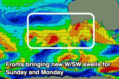 Behind the front a fresh pulse of mid-period W/SW swell is on the cards, generated by a strengthening fetch of strong W/SW winds through the Bight, with patchy embedded gales.
We'll see the Mid Coast continue around 2ft Sunday, while a secondary front pushing into us later is likely to bring more size to 2-3ft on Monday.
The South Coast will struggle with the westerly direction again but remain cleanest, with the size hovering between 2-3ft on Sunday, likely a little bigger through early next week.
The front moving through Sunday will bring a shift in winds to the W/NW on Sunday, shifting NW into the afternoon and then giving into a strong W/SW change Monday. Following this the swell looks to slowly settle down with improving winds, but we'll have a closer look at this Friday.
Comments
Lines at Middleton. And a rainbow!


Fun arvo of waves..