Fading small surf, windy, poor weekend

South Australian Forecast by Craig Brokensha (issued Wednesday 8th April)
Best Days: South Coast tomorrow morning, Monday and Tuesday next week down South
Recap
A good reinforcing S'ly swell yesterday offering plenty of size to 3-4ft off Middleton in the morning with light winds and decent conditions, easing later in the day and more this morning back from 3ft on the sets but with less favourably E'ly winds.
The Mid Coast was tiny yesterday and only suitable for beginners, near flat today.
This week and weekend (Apr 9 - 12)
We'll see the surf continuing to ease and drop out of the S'th across the South Coast over the coming days with no new swell sources since the low on the weekend that generated yesterday's S'ly groundswell.
Winds will improve and tend more E/NE-NE with easing 1-2ft sets off Middleton, under the forecast size as the models are incorrectly combining a long-period W/SW groundswell generated south-east of Madagascar with the existing easing swell.
Friday will be tiny and to 1ft or so off Middleton with a N/NW tending W/NW breeze through the morning, strengthening ing the afternoon kicking up a tiny windswell on the Mid Coast.
 Now, moving into the weekend we've got some consensus on what's expected and guess which forecast model won? ECMWF of course.
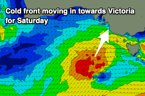
We're expected to see a strengthening polar frontal progression developing south-west of us and too late to generate any real swell, but a cold front spawning off the back of this is due to project up and into Victoria Friday evening and Saturday, bringing poor and strong SW tending S/SW winds.
It'll also bring a pulse of close-range S/SW swell as a fetch of strong to gale-force SW winds are projected through our swell window, kicking to 4ft into the afternoon Saturday, with plenty of windswell ahead of this in the morning. The Mid Coast will be choppy and to 1-2ft or so, nothing special at all.
The swell will ease Sunday with poor and moderate to sometimes fresh S'ly winds across the South Coast with easing 4ft sets off Middleton, tiny on the Mid.
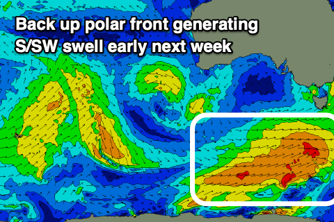 We've got better waves due into Monday and especially Tuesday as a polar frontal progression firing up through the weekend, with a fetch of initial W'ly gales weakening and shifting strong SW while moving through our southern swell window.
The swell from this source is due Tuesday, with Monday offering a bit less size down South but with N/NE offshore and weak sea breezes, 3ft+ Tuesday with similar winds.
Longer term a strong node of the Long Wave Trough moving in from the west next week looks to bring some stronger Southern Ocean frontal activity and increased swell activity from later week, but more on this Friday.
Comments
Let’s hope people adhere to the advice at the top of this page...the last week people certainly weren’t especially on the mid coast. Never seen so many people surfing for what was on offer. Fingers crossed.....