Stormy, windy weekend

South Australian Forecast by Craig Brokensha (issued Friday 3rd April)
Best Days: Protected spots South Coast Sunday, Mid Coast Monday morning, keen surfers South Coast Tuesday morning
Recap
Good waves across both coasts yesterday, great down South with plenty of swell continuing to 3ft off Middleton and weak sea breezes, 1ft or so on the Mid but pulsing to 1-1.5ft with the incoming tide.
Today the South Coast is the pick with plenty of clean and lined up swell and good sized sets across Middleton, back to the tiny 0.5-1ft stuff on the Mid.
This weekend and next week (Apr 4 - 10)
We've got a windy and stormy weekend on the cards though not quite as bad as it was looking earlier in the week.
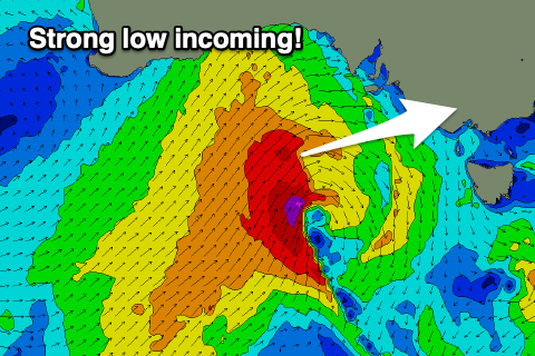 Currently a strong mid-latitude low has formed south of WA and it's generating a fetch of strong to gale-force W/SW-SW winds in our western and south-western swell windows as it moves east.
We'll see the storm moving across us this evening, bringing with it tomorrow strong W/SW winds and stormy waves on the Mid Coast, choppy down South.
Size wise a mix of stormy windswell and mid-period W/SW swell should come in at 3-4ft on the Mid Coast, with the South Coast building through the day from 3ft+ off Middleton, to that 4-5ft range into the late afternoon.
On Saturday evening a small embedded front will project a burst of W/SW gales through our south-western swell window, generating a reinforcing SW swell for Sunday afternoon, with the South Coast likely to hold around 4ft+ while the Mid Coast looks to drop back to 2-3ft.
Fortunately with this front moving through winds will tip back to the W/NW on Sunday morning, though fresh to strong, favouring protected spots down South (poor on the Mid Coast), with winds likely to dip back to the W/SW later in the afternoon.
Next week then looks average as a strong high moves in behind the weekend's storm activity, leaving S/SW tending S/SE winds on the South Coast as the swell swings more S/SW in direction. We'll see the weekend's swell easing but a new S/SW-S groundswell is due into the afternoon and more so Tuesday/Wednesday
This will be generated by a polar low stalling south-southwest of Tassie on the weekend, directing S/SW gales in our southern swell window.
Size wise, Middleton should still see sets easing from 3-4ft Monday (better and to 1-2ft on the Mid Coast with morning S/SE winds), with a drop back to 3ft, holding all day and then easing from 2-3ft Wednesday.
Winds will be stubborn though and out of the SE on Tuesday, possibly tending E/SE for a period, fresher and average E/SE on Wednesday.
Longer term the storm track will be focussed up east of Tasmania owing to a strong node of the Long Wave Trough developing across New Zealand. This means we'll hardly see any decent swell generating systems at all next week resulting in a small and average run of swell. More on this Monday. Have a great weekend!
Comments
Great satellite imagery of the incoming low..