Improving conditions with fun amounts of swell down South

South Australian surf forecast by Craig Brokensha (issued Wednesday 25th March)
Best Days: South Coast tomorrow morning, Friday morning, Saturday, Sunday morning, next week
Recap
Another good pulse of reinforcing groundswell through yesterday on the South Coast with 3-4ft sets off Middleton and workable conditions before becoming wind affected into the afternoon. Today the swell has dropped a bit with average conditions while the Mid Coast has been tiny to flat.
This week and weekend (Mar 26 - 29)
Later today a good new long-period S/SW groundswell is due to arrive across the South Coast, generated by a strong low that formed south of WA this week.
This swell is expected to peak tomorrow morning with good 3-4ft sets across Middleton, 0.5-1ft on the Mid Coast max if that, easing into the afternoon and further Friday.
The easing trend will be slowed through Friday by a weak polar front that's currently south-west of Tassie. This is producing a fetch of strong S/SW winds, with Middleton hanging around 3ft on the sets, tiny to flat on the Mid.
Winds will start to improve into tomorrow with a less than ideal but workable E/NE-NE morning breeze, shifting S/SE into the afternoon, NE Friday morning ahead of weak S'ly sea breezes.
Moving into the weekend and Saturday looks great for the exposed beaches with a N/NE tending N/NW and then variable later.
A new S/SW groundswell is due into the afternoon Saturday, generated by a poorly aligned polar front, but on the back of all the current activity it'll provide some fun sets. Middleton is likely to kick to 2ft+, easing back from 2ft Sunday as offshore winds persist from the NW, giving into a SW change.
 Next week onwards (Mar 30 onwards)
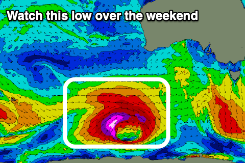
As touched on last update, we've got an intensification of the Southern Ocean storm track from this weekend into next week, generating what now looks to be one large long-period swell and plenty more moderate sized pulses.
A significant polar low is forecast to form east of the Heard Island region later Friday, with a broad fetch of severe-gale to storm-force W/SW winds due to be projected through our south-western swell window.
Currently the swell from this low is on track for Tuesday, building through the day and with local variable winds. We'll have a closer look at this Friday though.
Comments
Hey Craig, Lizzie here! Thanks for all your efforts with forecasting! Just wondering if you could share the finer details of potential surf for Pondi next week... Mon to Fri, thanks so much!
Hey Lizzie, sorry we don't provide spot specific forecasts or detailed notes for the Yorke Peninsula. Wouldn't be a bad place to isolate.
They have now closed Innes NP and all council camp grounds to camping.
Thanks Craig... no worries at all. Cheers everyone else for the closure updates! Take a lot more than that to stop surfing!
We've just cancelled our planned family trip to the Yorke next week - gutted! We've been looking forward to getting over there and away from all the craziness, but we're struggling to come up with reasons why it's "essential" travel, apart from a purely selfish perspective.
So as soon as we start seeing a pumping forecast, we are going through this shit storm where it’s not even advised to go outside unless essential... that’d be right! Surfers will be surfers, see u guys out there!