Great tomorrow, plenty of swell from the weekend but the winds..

South Australian Forecast by Craig Brokensha (issued Monday 16th March)
Best Days: Tomorrow down South, Wednesday morning down South at the magnets, Saturday morning South Coast
Recap
A poor weekend of surf with onshore winds and a junky mix of swells Saturday down South, a touch cleaner yesterday morning but still well below average. The Mid Coast was tiny and clean Saturday, near flat Sunday.
Today the surf is on the improve down South with a cross-shore breeze swinging more NE and cleaning up waves with a new building SW groundswell. Winds are due to swing back E/SE in the coming hours so try and surf now.
This week and weekend (Mar 17 - 22)
Tomorrow is the pick of the forecast period with all day fresh offshore N/NE tending lighter N/NW winds (variable late afternoon) along with an easing SW groundswell across the South Coast.
Middleton should see 2-3ft sets, with better waves across the more open beaches, tiny to flat on the Mid Coast.
Wednesday will be clean again but the swell small and fading from 1-2ft off Middleton, still OK on the magnets. A moderate offshore N/NW wind is expected, tending variable late afternoon ahead of possible weak sea breezes.
Thursday looks clean again with stronger offshore winds but a low point in swell and tiny waves down South. We'll see a change move through the afternoon as a weak mid-latitude low moves in from the west.
 A small increase in W/SW swell is due across the Mid Coast from this low, building Friday and reaching 1-2ft but with onshore W'ly tending W/SW winds.
The South Coast isn't expected to see any real size owing to the fetch around the low being too far north and the swell blocked by Kangaroo Island.
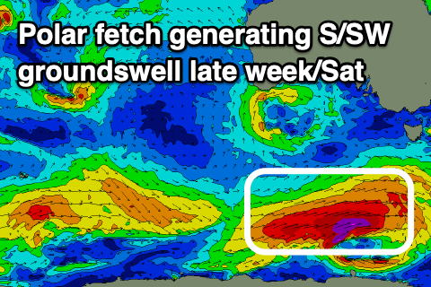
Very late in the day but more so Saturday we should see a new S/SW groundswell filling in across the South Coast, generated by the first in a series of strengthening polar fronts developing through our southern swell window – under the influence of a strengthening node of the Long Wave Trough.
Unfortunately the node will continue east across Tassie resulting in unfavourable winds from the south to south-eastern quadrant as the swells fill in.
Coming back to the first of the fronts and a great fetch of gale to severe-gale W/SW winds will be generated in our southern swell window over the coming days, with the swell due to kick strong late Friday to 3ft+ off Middleton, peaking Saturday morning to 4ft with what looks to be the lightest and best winds (light SE, swinging S/SW through the afternoon). The Mid Coast will be tiny owing to the swell direction as the W/SW windswell eases.
From Sunday we'll see stronger onshore winds down South and moderate to possibly large levels of S/SW groundswell from stronger polar frontal systems develop late week. We'll have a closer look at this on Wednesday.