Poor weekend, better waves into early next week

South Australian Forecast by Craig Brokensha (issued Friday 13th March)
Best Days: South Coast Monday until early afternoon, Tuesday, early Wednesday
Recap
Great waves across the South Coast swell magnets all day yesterday, tiny to flat on the Mid Coast, with a new swell filling in today but with winds shifting onshore. Protected spots were best early this morning ahead of the change proper.
This weekend and next week (Mar 14 - 20)
The weekend is looking mostly poor with today's change seeing winds out of the S/SE tomorrow and strong, whipping up a poor windswell as the groundswell eases.
Come Sunday winds are due to swing more E/SE through the morning, possibly even E for a short period but we'll be looking at a poor quality S'ly windswell easing from 2-3ft or so. The Mid Coast will be tiny to flat all weekend.
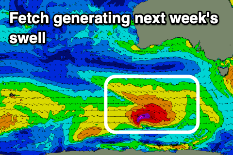 We'll see conditions improve and winds swing more E/NE-NE on Monday morning along with a building mix of new S/SW swells. These swells will be generated by a flurry of polar frontal activity along the polar shelf today and tomorrow, with an initial fetch of strong W/NW winds due to be followed closely behind by stronger W/NW gales as a low forms.
The fast eastward track of this progression isn't ideal but we should still see a good kick in size for exposed breaks through Monday (afternoon), easing Tuesday.
Monday morning looks to start slow and around 2ft to maybe 3ft off Middleton, building to 3ft+ into the afternoon with those morning E/NE-NE winds ahead of sea breezes.
Tuesday looks great as the swell eases from 2-3ft across Middleton with N/NE offshores, tending N/NW into the afternoon and then variable.
Come Wednesday we're looking at clean conditions again but the swell will be on the way out and easing from 1-2ft.
Moving into the end of the week and it looks like we'll see a series of back to back polar fronts strengthening through our southern swell windows from mid-late next week and into next weekend – under the influence of a strengthening node of the Long Wave Trough to our east.
At this stage with the node forming east of us it looks like winds won't be favourable, and more onshore out of the S/Se than offshore, but more on this Monday. Make the most of the current surf and have a great weekend!