Good swell this week, though average conditions

South Australian Forecast by Craig Brokensha (issued Monday 2nd March)
Best Days: No great days but for those with low expectations try Wednesday and Thursday morning
Recap
Solid and workable waves on the South Coast Saturday morning with improving winds and conditions towards midday ahead of sea breezes, even cleaner and pumping Sunday morning with offshore winds and a temporary low point in swell ahead of a large, late pulse of S/SW groundswell as winds shifted W/NW.
The Mid Coast was tiny and clean Saturday, near flat Sunday.
Today onshore winds have created poor conditions with plenty of size left from late yesterday down South, flat on the Mid Coast.
This week and weekend (Mar 3 - 8)
As touched on last update, the weekend was the one to make the most of as this coming week is looking average wind wise for the South Coast, spoiling a good new S/SW groundswell.
Tomorrow will see a low point in swell with average and moderate to fresh E/SE winds through the morning, back to the S/SE through the afternoon.
Later in the day but more so Wednesday we should see a good new moderate sized S/SW groundswell down South, peaking in the morning and easing through the afternoon.
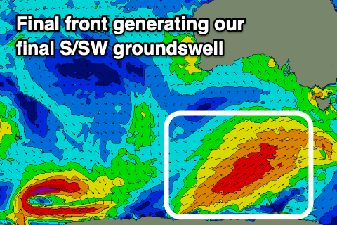 The swell was downgraded on Friday, but looking at the frontal system that's generating it currently to our south-southwest, I've upgraded the expected size a little.
This frontal system will be the last under the influence of the Long Wave Trough through our swell window, with an elongated fetch of strong to gale-force SW winds projecting north-east towards Tasmania through our southern swell window.
The swell should peak Wednesday morning to 4ft+ off Middleton, with our models over-forecasting the size, combining mid-period energy with the new groundswell energy.
Winds looks suss and from the E/SE-SE, but we may see a short period of E/NE winds through Wednesday morning ahead of S/SE sea breezes, average and moderate out of the S'th on Thursday with the S/SW groundswell easing from 3ft or so.
Through this whole period the swells will be too south to impact the Mid Coast, resulting in flat conditions.
Unfortunately we'll see a strong high moving in on Friday with winds out of the S/SW and a smaller leftover swell due to strengthen out of the S/SE through the weekend along with no decent groundswell.
This will block our swell windows through the weekend and into next week with only some small background S/SW groundswell on the cards for later next week. So all in all the outlook is fairly poor and it might be worth trying to surf the bumpy swell this week.
Comments
Oh my fucking god, when will this abominable run of surf end!?
It was firing on the weekend