Focus on the weekend

South Australian surf forecast by Craig Brokensha (issued Friday 28th February)
Best Days: South Coast all weekend and possibly Wednesday morning
Recap
After kicking strongly late Wednesday, the South Coast saw solid waves into yesterday morning but winds were only favourable for a very short period of time early, onshore from mid-late morning.
Today we've got a larger and more powerful swell on the build and early fresh onshore winds have now eased right back offering cleaner conditions for keen and experienced surfers. Size wise we should sets building to 6ft+ off the back of Middleton, bigger at deep water reefs and exposed breaks.
The Mid Coast has been hanging around 1ft or so for the most part, a touch stronger today but wind affected.
This week and next (Jan 29 – Mar 6)
Moving into the weekend and we've got much cleaner conditions due across the South Coast and with plenty of sizey swell to challenge yourself.
Today's large S/SW groundswell will ease back through tomorrow, likely from 4-5ft across Middleton, bigger at more exposed breaks and with a light E/NE-NE wind ahead of S/SE sea breezes, though without too much strength.
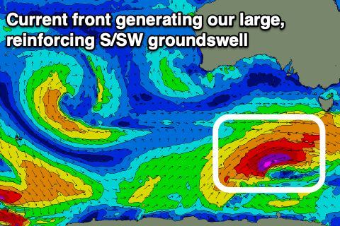 Sunday morning looks even cleaner now and great with a N/NE-N/NW offshore and temporary low point in swell ahead of a large new long-period S/SW groundswell into the afternoon. Middleton isn't likely to drop below 3ft+, while the new S/SW groundswell is currently being generated by a secondary strong frontal system, on the back of the one linked to today's swell, currently firing up west-southwest of Tassie.
This system will be stronger but shorter lived than the one linked to today's swell, with a great fetch of severe-gale to storm-force W/SW winds expected to be projected through our southern swell window.
The swell is due to arrive through the afternoon and reach 4-5ft+ late afternoon and evening, and winds will shift SW into the early afternoon, creating bumpy but workable conditions.
The Mid Coast isn't expected to see any real size all weekend, tiny and to 1ft on Saturday, even smaller Sunday with the swell coming more from the south.
Moving into next week and stronger S/SE winds are due in the wake of Sunday's SW change as a strong high moves in from the west. This will create poor conditions as Sunday's S/SW groundswell eases, possibly swinging more E/SE into Tuesday morning but continuing to create average conditions.
A new S/SW swell is due on Wednesday though as winds hopefully swing more E/NE, generated by a broad but relatively weak polar front firing up south-west of Tassie on Sunday.
A boost back to 3-4ft is expected on the South Coast, tiny on the Mid Coast, easing Thursday though we may see onshore winds kick back in. More on this Monday though. Make the most of the coming weekend!