Poor until next week, though mainly for the Mid

South Australian Forecast by Craig Brokensha (issued Wednesday 12th February)
Best Days: Mid Coast Tuesday afternoon and Wednesday
Recap
A building mix of W/SW swells across the Mid Coast yesterday, 1-1.5ft in the morning but kicking to 2ft+ into the afternoon though with bumpy and choppy conditions. It cleaned up late and this morning was cleaner, but back to an inconsistent 1-1.5ft at dawn, still hanging just in there into the middle of the day.
The South Coast remained poor with a slight increase in size yesterday, windswelly and even worse today.

Little runners late morning today
This week and next (Feb 13 - 19)
There's no quality surf due at all over the coming days until we see next week's new W/SW groundswell filling in.
The Mid Coast will fade back in size and become tiny tomorrow, flat into Friday with poor onshore winds down South and low quality windswells.
Moderate SE-S/SE winds are due tomorrow on the South Coast, fresher S/SW into the afternoon and then SW Friday, strengthening through the day.
Winds will remain strong and tend S/SE into Saturday, easing off a bit in strength Sunday though still remaining from the same direction. This will leave no quality surfing options at all.
Looking further ahead into next week and SE tending S/SE winds will persist down South, clean on the Mid Coast but still tiny.
Into Tuesday and Wednesday we should see a fun new W/SW groundswell filling in, generated by a frontal progression firing up towards Western Australia later this week and on the weekend.
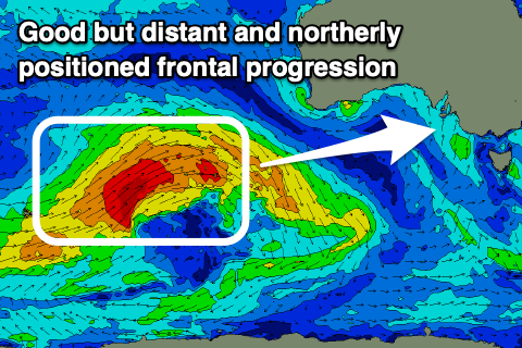 It'll develop around the Heard Island region tomorrow evening and project a fetch of W/SW gales ideally through the Mid Coast's western swell window, weakening once directly south-west of WA but have a little wag in the tail, prolonging the swell event.
The swell is due to build through Tuesday afternoon, reaching a good 2ft on the Mid Coast, holding Wednesday morning and then starting to ease later but more so Thursday from 1-1.5ft.
The South Coast should build to 2-3ft from Day St to Goolwa later Tuesday but peak Wednesday around 3ft+, though S/SE-SE winds will create poor conditions and favour the Mid. Make the most of this swell as following it, there's still nothing significant on the cards or favourable winds until at least the following week. More on this Friday.
Comments
What will be the best spots to surf at Innes National Park on Tuesday next week? Thanks