Lots of surf on the way and with decent conditions

South Australian Forecast by Craig Brokensha (issued Wednesday 22nd January)
Best Days: Both coasts mosts days from Friday
Recap
A solid kick in stormy windswell across the South Coast yesterday but with poor conditions, tiny on the Mid Coast and to 1ft or so but cleaner.
Today conditions have cleaned right up down South but the swell dropped right back in size, tiny to flat and bumpy on the Mid. An onshore change has since moved through across both coasts, generating poor surf.
This week and weekend (Jan 23 – 26)
Today's onshore change is linked to a strong mid-latitude front-come low that's moving in from the Bight.
 A good fetch of strong W/SW winds have been generated in our western swell window, while tomorrow we'll see an additional fetch of strong to near gale-force W/SW winds projected up and through the South Coast's south-western swell window.
We should see easy 3ft surf out of the W/SW tomorrow across the Mid Coast but with strong W/NW tending W/SW winds. The South Coast will be clean in protected spots early, but the swell on the weak side and west, coming in around 2ft+ across the Middleton stretch, but reaching 3ft or so later in the day.
Friday will provide the most size on the South Coast, with the swell peaking into the afternoon to a good 4ft off Middleton, while the Mid Coast should drop slightly to 2-3ft. Conditions look great for the South Coast Friday morning with a W/NW-NW offshore, shifting W/SW later morning, while the Mid will be onshore but workable for the keen.
Saturday is looking much cleaner on the Mid Coast with a variable morning breeze and fun surf in the 2ft range. The South Coast will also be clean with a light NW offshore and easing 3ft waves off Middleton ahead of S'ly sea breezes.
Sunday should be clean again with morning variable winds and a further drop in swell from across both coasts.
Next week onwards (Jan 27 onwards)
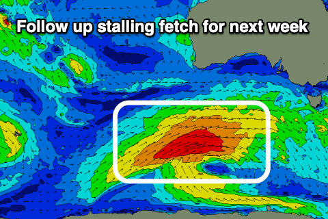
Moving into next week, our good run of SW swell from Monday through Thursday is still on track, with a broad and stationary polar low due to generate multiple slow moving fetches of strong to gale-force W/SW winds through our south-western swell window.
 Initially a small and tight polar low will generate a fetch of W/SW gales in our distant swell window, producing an inconsistent SW groundswell for later Sunday but more so Monday morning. Inconsistent 2-3ft sets are due on the South Coast, tiny on the Mid, while into the afternoon some new mid-period SW swell should build, followed by SW groundswell on Tuesday.
This swell will be generated by a broader fetch of strong to gale-force W/SW winds south of WA with Tuesday offering the most size to 4ft off Middleton, 1-1.5ft or so on the Mid Coast on the favourable parts of the tide.
Local winds look favourable Monday morning and variable tending offshore, good across the Mid Coast Tuesday morning and hopefully early W/NW on the South Coast. Light to moderate S/SE winds are expected on Wednesday as the swell slowly eases, E/NE Thursday morning.
Longer term we've got a good W/SW groundswell on the cards for next weekend, but we'll have a closer look at this Friday.