Easing surf ahead of good weekend W/SW swell

South Australian Forecast by Craig Brokensha (issued Wednesday 8th January)
Best Days: South Coast tomorrow morning, beginners on the Mid Coast, early Friday South Coast, Saturday and Sunday Mid Coast, Monday morning South Coast
Recap
Not too bad down South yesterday morning with a light onshore wind but small mix of swells. The Mid Coast hung in around 0.5-1ft but today a new mix of W/SW and SW groundswell have filled in. The Mid Coast is seeing a bit more size then expected and to 1-1.5ft, while the South Coast is seeing good 3ft sets across the Middleton stretch.
This week and weekend (Jan 9 – 12)
The polar low (remnants of TC Calvnia) linked to today's swell was slow moving and long-lived and as a result, while a peak in size is due this afternoon across the state, we'll see the easing trend tomorrow be drawn out.
We should see easing sets from 3ft+ along the Middleton stretch, 1ft+ on the Mid Coast as winds improve down South and swing fresh NE, tending more E'ly into the afternoon ahead of late sea breezes.
Friday morning will hopefully see a W/NW breeze early ahead of a SW change, but the surf will be small and easing from 1-2ft.
 Moving into the weekend, we've got a good new W/SW groundswell due on Saturday, while a deepening front/low late in our swell window should generate an additional mid-period S/SW swell for Sunday down South, and S'ly groundswell Monday.
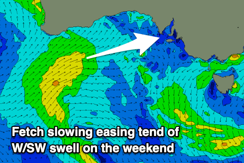
The W/SW swell is looking good, with a low forming north-east of the Heard Island region earlier this week generating a fetch of strong to gale-force W/SW winds in our western swell window while projecting east.
The low is weakening south-west of WA but will continue to generate a favourable fetch under WA tomorrow and through Friday.
This will prolong the swell event, with the initial W/SW groundswell due to fill in Saturday, kicking to a good 2ft across the Mid Coast, dropping back to 1-2ft on Sunday. The South Coast should see sets building to 2ft+ but mixed in with windswell and along with fresh S/SE winds, favouring the Mid Coast.
Sunday will become slightly better down South with an E/SE breeze, though moderate in strength along with a bit more swell to 3ft+ off Middleton, better on the Mid Coast.
Now, come Monday a pulse of S'ly groundswell is likely, generated on the backside of the low forming south-west of Tassie on the weekend. Size wise it only looks to be 2-3ft or so but with morning offshore winds ahead of a S/SW change.
Longer term a strong polar low forming south of WA on Sunday should produce some good new W/SW groundswell the middle of next week but with onshore S/SE winds. Check back here Friday for more on this.