Poor weekend, better mid-late next week

South Australian Forecast by Craig Brokensha (issued Friday 3rd January)
Best Days: Today on the South Coast, South Coast Wednesday morning and early Thursday
Recap
Another good day of surf across both coasts yesterday with cleaner conditions than expected down South and good 3ft sets from Middleton to Goolwa, hanging in at 2ft on the Mid Coast.
Today the Mid was tiny and clean early but now bumpy, best down South with 2ft+ of smaller swell, best at Waits and Parsons. Make the most of today as the coming period is poor.
This weekend and next week (Jan 4 – 10)
As touched on just above, make the most of today's clean and fun waves on the South Coast as the coming period is generally poor until later next week.
A strong onshore change is due move through this evening and persist out of the S/SW tomorrow producing a tiny S/SW windswell on the Mid Coast and a junky windswell for the South Coast.
Sunday isn't looking any better with easing levels of S/SW windswell with a fresh and gusty S/SE-SE morning breeze. The Mid will be tiny.
We may see winds tend E/NE on the South Coast Monday morning, but the swell will be small, weak and easing. Dropping from 1-2ft off Middleton max and tiny on the Mid Coast.
We then look towards the track and developments of Tropical Cyclone Calvinia from the east coast of Madagascar into the westerly storm track.
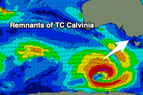 TC Calvinia is in the southern Indian Ocean and is expected to dip east-southeast and into our swell window on Sunday, with a pre-frontal fetch of W/NW gales being followed by a post-frontal fetch of gale to severe-gale W/SW winds as a low forms and stalls to the south of WA, near the polar shelf.
We should see an initial pulse of small SW groundswell Tuesday afternoon, ahead of the better SW groundswell Wednesday, peaking into the afternoon.
Size wise, the Mid Coast isn't due to see much size, with sets to 1ft, while the South Coast should build to 3ft+ Wednesday afternoon, easing from a similar size Thursday morning.
Conditions looks much better into Wednesday and Thursday with a N/NE offshore wind on the former ahead of sea breezes, similar early Thursday ahead of a S/SW change.
Longer term the swell will ease with onshore winds into the end of the week and weekend, but more on this Monday. Have a great weekend!
Comments
goolwawatu shore break was firing this morning :)
Parsons was closing out and about as packed as ya can get ☹
Heard and seen opposite to that, peaky and fun, but packed yes.
Good to see you on here JR :-)