Looking towards the west

South Australian surf forecast by Craig Brokensha (issued Monday 23rd December)
Best Days: Keen surfers tomorrow morning and dawn Wednesday South Coast, Mid Coast Friday, South Coast Saturday morning
Recap
Poor, small, onshore waves on the South Coast to kick off the weekend, tiny on the Mid, while a large new S/SW groundswell due for yesterday was a little undersized at dawn as expected but kicked in very solidly through the mid-morning, with large, powerful and maxing waves across the South Coast but with less than favourable winds.
Some reports from around Chiton late afternoon were of some very solid and large sets.
Today, the swell was still large but with less than ideal winds, workable for keen and experienced surfers at selected breaks down South, tiny on the Mid with the southerly swell direction.
Looking at the Cape du Couedic buoy you can see how S'ly the swell now is from the 'bombing low' with it registering around 180 degrees. Rare with such size and power in South Australia. This direction also provided a wide variation of size across spots west of Adelaide, with the shadowing and blocking of certain land masses.
This week and weekend (Dec 24 - 29)
Down, down, down.
Our current large S'ly groundswell will ease in size and power over the coming days as winds slowly improve down South.
The Mid Coast will become tiny to flat, while easing sets from 3ft to possibly 4ft are due off Middleton but with a moderate E'ly breeze, likely tending E/NE times ahead of sea breeze, so try spots that like an easterly wind.
A more variable breeze is expected early on Wednesday morning but the swell will be smaller and dropping from 2ft or so off Middleton with S'ly winds kicking in from mid-morning. So aim for the early if you're keen for a wave. Thursday will be a lay day with S/SE winds and a junky windswell down South.
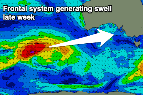 Our good W/SW groundswell for late week is still on track, with a great frontal progression forming west-southwest of WA yesterday, projecting a good fetch of W/SW gales through our western swell window. The front is currently weakening south-west of WA, with the swell due to arrive late Thursday but peak Friday, best on the Mid Coast.
There's no change to the expected size on Friday with good but inconsistent 2ft+ sets due on the favourable parts of the tide with small and inconsistent 2-3ft sets from about Day St to Goolwa.
Winds will favour the Mid Coast, E/SE tending E/NE ahead of sea breezes, with the South Coast not too favourable with an E/SE-E breeze.
Saturday is the pick for the South Coast as the swell eases from a small and inconsistent 2ft off Middleton, best at Waits and Parsons with a N/NE tending NW breeze ahead of a shallow change. The Mid Coast will likely be back to 1-1.5ft at best.
Longer term we've got plenty more W/SW swell on the cards into next week with back to back strong mid-latitude storms forecast to fire up to the south-west and under WA, but more on this Wednesday. Merry Christmas!