Large, though onshore swell on the way

South Australian surf forecast by Craig Brokensha (issued Friday 20th December)
Best Days: Selected spots Sunday afternoon, Monday morning and Tuesday morning, Mid Coast Friday
Recap
Tiny onshore waves across the South Coast yesterday, mild and away from the heat further north, while today the offshore wind has kicked in, and temperatures are on the rise with a small, clean swell best suited to the swell magnets.
A new W/SW swell due on the Mid Coast was a little delayed at dawn yesterday and only to 1ft or so, but the swell peaked into the afternoon, helped a little by the small incoming tide with sets to 1-1.5ft across the magnets, tiny and bumpy today.
This weekend and next week (Dec 21 - 27)
Moving into the weekend, and a cool onshore change due into this evening will leave S/SE winds across both coasts into tomorrow but with no new swell.
 It'll be a lay day ahead of a large, powerful and long-period S/SW groundswell building through Sunday.
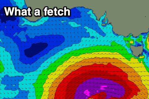
A large and deep low is currently forming south-west of us today.
There's been no real change to the strength and longevity of this system, with a fetch of severe-gale to storm-force W/SW winds developing initially in our south-western swell window later this afternoon and evening, pushing slowly east and more into our southern swell window tomorrow, only weakening once passing under Tassie tomorrow evening and out of our swell window Sunday morning.
A large, pro-longed and long-period groundswell event will impact the state from Sunday through Tuesday, with the first and largest pulse of S/SW groundswell due to fill in Sunday.
The swell is likely to be undersized at dawn Sunday, kicking rapidly and solidly through the day ahead of a peak into the late afternoon/evening.
Most exposed breaks to the S/SW groundswell should reach 6-8ft into the afternoon, with larger waves on the deep water reefs, especially into the evening. The Mid Coast looks tiny with the southerly direction, though an additional W/SW swell should provide 1-1.5ft sets on the favourable parts of the tide.
Winds on Sunday unfortunately look average, moderate to fresh SE at dawn tending E/SE and easing for a period in the morning ahead of S/SE sea breezes.
The Mid looks clean in the morning, with afternoon sea breezes.
Monday morning will remain large, with the swell starting to ease while swinging more south in direction, but still coming in at an easy 6ft on the sets across the South Coast, easing slowly and more noticeably from 3-4ft on Tuesday morning off Middleton.
 The Mid Coast will become tiny and to 1ft Monday, near flat Tuesday.
Winds will remain an issue, light to moderate but workable from the E/SE-SE in the morning ahead of S'ly sea breezes, similar Tuesday but lighter E/SE in the morning.
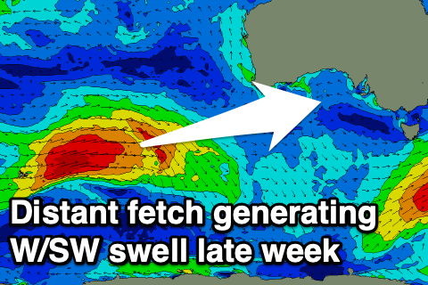
Christmas Day looks a little better with a lighter and more variable breeze out of the S'th, but easing mix of swells from 2ft or so off Middleton. Only for the desperate and keen. Moving into the end of the week, S/SE winds will create poor conditions and a junky windswell on the South Coast, but a fun W/SW groundswell is due on the Mid.
This swell will be generated by a strong but distant front forming north of the Heard Island region tomorrow, projecting a fetch of W/SW gales through our western swell window, south-west of WA, weakening into Monday evening.
The swell is looking a little better than on Wednesday, and ideally in the Mid Coast's swell window, with the W/SW groundswell arriving overnight Thursday and peaking Friday. Good 2ft+ waves are due on the favourable parts of the tide with offshore E/SE winds, but we'll have a closer look at this on Monday. Have a great weekend!
Comments
Boy that's an active bouy.
Fair bit of size at Knights at the moment looking at the surf cam.Got sent some photo’s of third ramp at Robe this morning looking very nice with an ese off- shore!!
Geez it come up Bigger than i realized today! some impressive swell on the cs & cdc bouys.
The bombing low producing the goods
Very rapid increase in swell size at Yorkes this morning. Good to see.
Yep very rapid kick at Yorkes, but very south as well. Into only a select few breaks and missing others. Love witnessing such a large, powerful south swell impacting the coast. Never been over there for one. Scored some great waves.
Only was sent once to Yorkes for work, quite liked it and didn't get to check the surf too much, did the Wallaroo ferry from memory.
The Eyre I worked at quite a bit more, and one swell I was surprised to see bombies breaking outside towns half way up the East Coast while driving back toward Adelaide. With a very south swell, would waves get all the way up near Whyalla? Did KI block the swell on the Yorkes east coast?
Could have been an epic novelty spot day on the Eyre or the West Coast of the Yorkes?.
Yeah there are waves up inside the gulf, fickle and more fun peelers than anything serious, and yeah the east coast of Yorkes is totally blocked from any swell by KI.
Yorke's has every level of commitment covered when it's on.
And crowd to go with it.