Small W/SW swell ahead of a large S/SW groundswell

South Australian Forecast by Craig Brokensha (issued Wednesday 18th December)
Best Days: Mid Coast tomorrow and keen surfers Friday morning, South Coast swell magnets keen surfers Friday, experienced and keen surfers selected spots Sunday through Tuesday, South Coast Wednesday morning
Recap
Cleaner conditions yesterday morning with a smaller swell, best at Waits and Parsons before winds shifted more E'ly, tiny and clean on the Mid Coast.
Today the swell has bottomed out under hot offshore winds, with the ocean better for a swim than surfing.
This week and weekend (Dec 19 - 22)
Looking into the end of the week, and we'll be expecting a fun new W/SW swell across the Mid Coast tomorrow, and a slightly better and cleaner S/SW swell on the South Coast Friday.
The inconsistent W/SW swell was generated over the weekend, west-southwest of WA and performed well across their region yesterday and today.
The tides aren't ideal for us over the coming days with big morning highs, less so into the afternoons so expect less of a kick than normal. Dawn tomorrow will be the pick as the tide continues to push in with 1-2ft sets expected across the Mid Coast swell magnets, slower and smaller on the other side of the tide. Friday looks to come in similar, if not a little smaller and to 1-1.5ft.
Looking at the South Coast and a slight kick in size is expected tomorrow, but only to 1-2ft off Middleton and with unfavourable S/SE-SE winds, clean on the Mid with an E/SE offshore, only tending SE through the day.
On Friday winds will shift strong NE and N/NW into the afternoon ahead of a late SW change, bringing in the heat.
Down South, a slightly better swell is expected, generated by a weak front currently pushing towards Tassie. Fun 2ft sets are due off Middleton, better across the swell magnets, but tricky and not great with the strong offshore wind.
Come Saturday conditions look poor across all locations with a fresh and cooler S/SE breeze in the wake of Friday's afternoon change.
We then look to the 'bombing low' forecast for the Southern Ocean late week, with it deepening significantly in our southern swell window before moving slowly east over the weekend.
For a storm to be classified as a 'bombing low' it has to drop 24hPa in 24 hours, with the southern most low of a pair of lows moving in from the south-southwest of WA due to just meet those requirements through Friday.
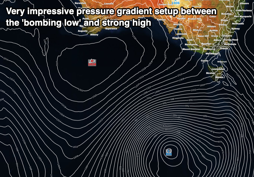
We'll see the low bottom out to a very impressive 953hPa along with a 1024hPa high pressure system squeezing its western flank, resulting in the development of a significant storm-force fetch of W/SW-SW winds in our south-western swell window.
The low will move slowly east while weakening slowly, projecting a fetch of severe-gale SW-S winds more through our southern swell window before passing under Tassie and out of our swell window Sunday morning, prolonging the large swell event.
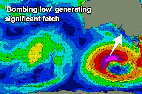 A large, long-period and powerful S/SW groundswell will be generated from the initial stages of the low building rapidly through Sunday morning and peaking into the afternoon. The South Coast should see easy 6-8ft sets across most exposed breaks into the afternoon, bigger on the deep water reefs, with the Mid Coast likely to come in around 1-1.5ft or so, with a tiny W/SW swell in the mix.
Winds will be fresh to strong out of the SE, tending E/SE while easing through the morning, tending S/SE into the afternoon.
The swell will still be large come Monday morning and to 6ft+ across the South Coast, back to 1ft or so on the Mid Coast and with lingering S/SE-SE winds. Winds won't improve until mid-week when the swell will be all but gone, owing to the strong high taking its time to drift west.
Longer term, a good frontal progression is expected to fire up in the south-east Indian Ocean late in the weekend and early next week, generating a fun W/SW swell for later next week/weekend, but more on this Friday.
Comments
Anyone out west?
Ceduna was 41.0 degrees Monday, 44.9 degrees yesterday, and it cracked 46.5 degrees around 1:43pm today.
Forecast for Thursday is 43 degrees.
Forecast for Friday is 43 degrees.
It’s cooking!
Got a couple of mates out there right now and they've been getting some nice waves with not too many around. Think today was pretty much flat tho.
45 and windy forecast for Friday here in the Hills - Catastrophic fire conditions. It's been pretty horrific the last couple of days and two more to go before the temps drop back down to bearable.
Shame you blokes couldn't line up the offshores with the bombing low swell - dropped the ball there fellas.
Hey Craig
How long do you reckon it takes for the swell passing the cape to hit the mid?
Started to show the new swell,)
Simple equation to remember is 2.81*period = speed of the swell (km/h). You can do the maths from there :)
Thanks mate.
Usually about 6hrs depending on the tide /wind & prayers!! Lol
New December record for Ceduna, 47.7!
49.2 Nullabor and 48.8 Ceduna new records!
Relative humidity at Nullabor is just 3%.
Interesting, the BOM's "Apparent temp" is 38.3 (it's been 9-10 degrees cooler than actual temp through most of the day).
Dunno if it feels ten degrees cooler though.
New December national heat record. Nullabor 49.9 beating Birdsville’s 49.5.
Ceduna topped 48.9.
Wow. Temp still climbing in Adelaide.. just reached 44.5 at half past five.
Noarlunga reached a mere 43 degrees but Victor was the place to be - Hindmarsh Island topped out at 25!
IS hot. Doing exercise for minimum wage today. Nasty business.
Air temps at 5:30am.
Noarlunga: 36.7°C
Adelaide: 36.2°C
Ceduna: 31.2°C
Nullabor: 30.1°C
Hindmarsh Island: 27°C
Stenhouse Bay: 23.2°C
Half an hour later - 6am - and it's now 37.7°C at Noarlunga.
Bloody hell.
Im glad those idiots finally decided to cancel the horse racing.