Lots of swell for the Mid, though the winds

South Australian Forecast by Craig Brokensha (issued Friday 1sy November)
Best Days: Both coasts tomorrow (Mid Coast early), keen surfers Mid Coast Sunday, South Coast Sunday morning, early Monday and Tuesday morning, Mid Coast Tuesday morning
Recap
Windy small waves across the South Coast yesterday, best at the magnets but not great, while small and onshore this morning. Winds have since improved down South, more variable and the swell is straight and relatively clean.
The Mid Coast has backed off slowly in size since Wednesday but a new inconsistent W/SW groundswell due this afternoon is showing on the Cape du Couedic wave buoy and we should hopefully see sets kicking to 1-1.5ft with the incoming tide later this afternoon, with Middleton reaching 2ft+.
This weekend and next week (Nov 2 - 8)
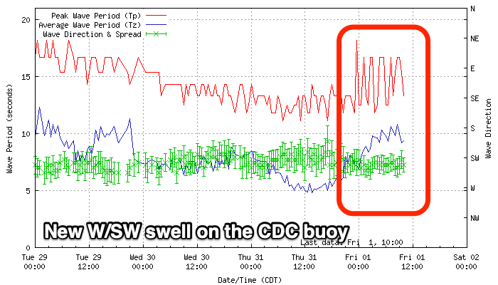 This afternoon's increase in inconsistent W/SW groundswell is due to hold into tomorrow morning, but our stronger pulse of W/SW groundswell will override it. This swell is still on track, with a tight and intense low forming south of WA and producing a short-lived burst of W/SW gales in our swell window yesterday.
Satellite observations picked up a tight bunch of storm-force winds around the core of the low, so it's not out of the question that we'll see the odd bigger set across the South Coast as the swell peaks through the day, but this part of the fetch wasn't aimed favourably towards us.
Size wise, Middleton should see good 3ft surf tomorrow, with the Mid Coast seeing 2ft sets. Later in the day some new mid-period W/SW swell may push the Mid Coast above this, though more so Sunday.
Looking at the winds, and both coasts should be clean early with a N/NW offshore down South, N/NE across the Mid Coast, with winds shifting more NW later morning and early afternoon ahead of a mid-afternoon W/SW-SW change.
Coming back to the new mid-period W/SW swell due into Sunday, and behind the strong low, a great fetch of strong W/SW winds were projected under WA and through the Mid Coast's swell window, with the front currently pushing in through the Bight.
This will generate a larger mid-period W/SW swell for Sunday to 3ft on the Mid Coast, while the South Coast looks to ease back a touch to 2-3ft off Middleton.
Winds look great for the South Coast early and N/NW again, but shifting quickly to the W/NW ahead of a late morning W/SW change. The Mid Coast will be bumpy but workable all day, though messier into the afternoon with an increase in wind strength.
A slow drop in size should be seen on Monday from 2-3ft on the Mid Coast on the favourable parts of the tide and 2-3ft off Middleton, but a fresh W'ly tending SW breeze will continue to create average conditions on the Mid, clean early down South with a W/NW breeze.
Tuesday looks a touch better on the Mid with a possible variable breeze, though smaller, easing 1-2ft surf, clean down South but small and easing from 2ft.
As talked about last update, a stronger mid-latitude storm moving in towards us through early next week is due to generate a larger W/SW groundswell for late week.
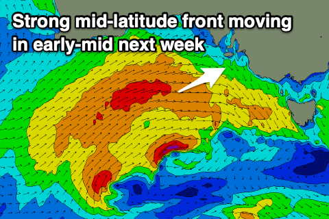 The initial stages of this storm will be a tight and intense low in the southern Indian Ocean, generating a fetch of severe-gale to storm-force W/SW winds in our far swell window. The low is then expected to weaken and turn into a front while projecting up towards the Bight, with an embedded fetch of W/SW gales pushing into us early Thursday.
A large mix of mid-period and groundswell energy are expected to build Thursday, backing off slowly from Friday but with strong winds from the W/SW.
Stormy surf is expected on the Mid Coast Thursday to 4ft with those strong to near gale-force onshore winds, with windy and choppy 4-6ft waves developing down South, cleaner and easing Friday morning. We'll have a closer look at the timing and size of the swells on Monday though. Have a great weekend!