Fun surf every day this period

South Australian Forecast by Craig Brokensha (issued Monday 30th September)
Best Days: South Coast tomorrow morning, but more so Wednesday morning at the magnets, Thursday morning South Coast, Friday morning South Coast magnets, Saturday both coasts, Sunday morning South Coast
Recap
Small, clean 1-2ft waves across the Mid Coast swell magnets on Saturday morning, tiny and back to 1-1.5ft yesterday.
The South Coast offered a kick in size and clean/peaky waves Saturday morning, still fun yesterday with a more variable S'ly breeze through the morning.
Today our secondary pulse of SW groundswell has filled in with a kick in size to 4ft along the Middleton stretch, but not the cleanest with winds from the E/NE, better on the Mid with inconsistent 1-2ft sets on the magnets.
This week and weekend (Oct 1 - 6)
Today's swell will ease off steadily over the coming days as winds improve for the South Coast, best Wednesday but for the swell magnets as the surf becomes small.
The Mid Coast will become tiny into tomorrow and back to 1ft or so, with easing 3ft+ waves off Middleton along with a fresh NE morning breeze, E/NE-E into the afternoon.
Come Wednesday Middleton is due to ease from 1-1.5ft, better at Waits and Parsons with a fresh N/NE tending N/NW breeze, easing off late in the afternoon.
We've got an upgrade in the S/SW groundswell due on Thursday with the polar storm linked to it, being a little stronger than forecast on Friday.
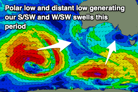 A polar low will form late in our swell window, generating a good fetch of W/SW gales south-west of Tassie today and tomorrow morning.
A fun S/SW groundswell should arrive overnight Wednesday and peak Thursday morning to 3ft on the sets off Middleton, 4ft sets at Waits and Parsons, while an inconsistent mid-period W/SW swell should provide 1-1.5ft sets on the Mid Coast.
Winds look a little dicey but mostly variable in the morning, swinging SW to S/SE as a trough moves through.
Friday looks a little better as winds tend E/NE through the morning down South, but with small easing sets from 1-2ft off Middleton, tiny on the Mid Coast.
Of greater importance is our W/SW groundswell due for the weekend, with a broad, strong and intense low currently sitting around the Heard Island region.
A fetch of severe-gale W/SW winds are being generated in our far swell window, with the low moving slowly east while slowly weakening over the coming 24 hours, breaking down tomorrow evening.
This will generate a moderate sized but inconsistent W/SW groundswell for the weekend, arriving late Friday and peaking Saturday to an inconsistent 2ft on the favourable parts of the tide across the Mid Coast and 3ft to 4ft along the Middleton to Goolwa stretch.
Winds look great and from the NE-N/NE through the morning ahead of possible afternoon sea breezes, strengthening NW tending W/NW Sunday as the swell fades and a mid-latitude low moves in and across us.
A small spike in mid-period swell is due in the wake of this change Monday, with some better groundswell potential into the rest of next week. More on this Wednesday though.