Good long-period swells inbound with varying winds

South Australian Forecast by Craig Brokensha (issued Friday 27th September)
Best Days: Saturday morning, Sunday and Monday keen sufers, Tuesday morning South Coast, early Wednesday South Coast
Recap
Tiny waves across Middleton yesterday and early today ahead of an onshore change, best across the exposed beaches, while the Mid Coast has been tiny to flat.
This weekend and next week (Sep 28 – Oct 4)
There's been no change to our inconsistent long-period and long-range SW groundswell, with it impacting Western Australia yesterday afternoon (today's WOTD) on forecast and pumping into this morning with offshore winds across the marquee reefs.
We'll see this swell possibly showing late today, but the bulk of the energy will fill in tomorrow, peaking to a good 3-4ft off Middleton (possibly the rare bigger sneaker), and 1-2ft on the Mid Coast on the favourable parts of the tide.
The swell will then ease through Sunday from 3ft+ off Middleton, but likely steady through the day as a reinforcing W/SW swell fills in from a pre-frontal fetch of W/NW winds currently south of WA. The Mid looks to drop back to 1-1.5ft.
Winds are still looking favourable for both coasts tomorrow, E/NE on the Mid in the Morning and E/NE-NE down South, though a little peaky and lumpy. Afternoon sea breezes will kick in across both coasts and Sunday looks average down South with a S/SW onshore, only moderate in strength, best on the Mid with a morning E/SE offshore ahead of sea breezes.
We then look towards the secondary long-period SW groundswell for Monday, with this one being more consistent and a little bigger in size.
The secondary polar low formed east of Heard Island yesterday, generating a fetch of severe-gale to storm-force winds in our far swell window. The low is a little weaker now and pushing slowly east, generating a fetch of weakening severe-gale W'ly winds, and will pass under Tassie on Sunday.
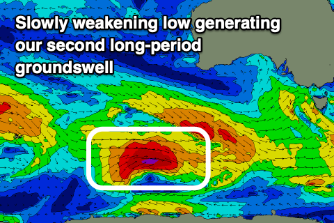 I've made a slight upgrade to the expected size, with Middleton due to come in at 4-5ft, but with the swell having a little more south in the direction, the Mid Coast only looks to persist at 1-1.5ft on the swell magnets.
Winds are a bit hit and miss, more E/NE than NE across the South Coast, clean on the Mid but as stated above tiny.
Tuesday looks the pick with easing sets from 3-4ft off Middleton and a better moderate to fresh NE offshore, likely tending N/NE at times ahead of sea breezes.
Wednesday will be OK early with a NW breeze, though shifting quickly to the W/NW and then SW with a shallow change.
Longer term an inconsistent mid-period W/SW swell is on the cards for Thursday, though a better and larger W/SW groundswell looks on track for next weekend.
A strong and slow moving low forming around the Heard Island region Sunday evening will slowly push east, generating a moderate to large sized W/SW groundswell for later Friday and Saturday week. More on this Monday though. Have a great weekend!