OK weekend, better swells and winds next week

South Australian Forecast by Craig Brokensha (issued Friday 6th September)
Best Days: Saturday and Sunday mornings protected spots on the South Coast, Tuesday through Thursday South Coast, Mid Coast Tuesday and Wednesday mornings
Recap
Good clean 2ft waves on offer yesterday morning with light winds on the Mid, bumpy and a bit bigger into the afternoon while choppy and semi-stormy today with stronger onshore winds.
The South Coast was great yesterday morning, though bumpy into the afternoon, poor today with stronger W'ly winds and no real size. A strong mid-latitude low is moving across us and this will kick the Mid Coast to a stormy 3-4ft with a late increase in size down South.
Today’s Forecaster Notes are brought to you by Rip Curl
This weekend and next week (Sep 7 - 13)
The strong mid-latitude currently moving into us will clear off to the east tomorrow, but a secondary weaker trailing front will push up and into us, shifting winds around to the W/SW across all locations, moderate to fresh in strength. With this, Victor is likely to see a morning W/NW breeze and mid-period S/SW swell to 3-4ft off Middleton.
The Mid Coast will be bumpy and back to 2ft to occasionally 3ft.
Sunday is looking cleaner and better but with a bit less size, W/NW in the morning, shifting stronger W/SW early afternoon as a front clips the state.
A mix of leftover close-range S/SW swell and easing S/SW groundswell from a fetch of pre-frontal W/NW winds just on the edge of our swell window the past couple of days is due.
Middleton only looks to come in around 2ft+, with the Mid Coast seeing small bumpy 1-2ft waves.
 The front clipping the state will generate a fetch of strong S/SW winds through our swell window Sunday evening, kicking up a new pulse of mid-period S/SW swell Monday morning to 2-3ft off Middleton but with onshore S/SW winds. The Mid Coast looks to come tiny and remain bumpy.
Tuesday will clean up rapidly as winds shift back to the N/NE and a very inconsistent and long-range W/SW groundswell is due to build, peaking overnight and easing Wednesday as a better and more consistent SW groundswell fills in.
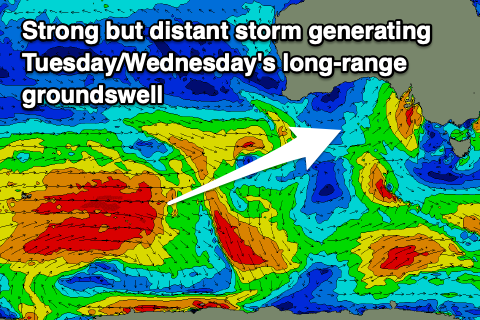
The long-range swell has and is still being generated by a very strong low that formed south-east of South Africa and moved slowly east through the Indian Ocean, generating a fetch of severe-gale to storm-force W/SW winds in our far swell window.
The swell will be very inconsistent but should build Tuesday and reach 4ft into the afternoon off Middleton with 2ft sets on the favourable parts of the tide across the Mid Coast. The closer-range SW groundswell is forecast to be generated by a tight and deepening low south-west of WA Sunday, with a fetch of severe-gale to storm-force W/SW winds generated in our swell window.
This swell is expected to peak Wednesday with sets continuing to 4ft off Middleton, and an inconsistent 2ft on the Mid Coast.
Winds will remain favourable for the South Coast and out of the N/NE, good early on the Mid and NE before shifting more N/NW.
Another low forming on the back of this initial system may generate a secondary SW groundswell for Thursday but the models diverge on the strength of this system at the moment, with the more reliable EC being weaker.
Either way winds look to be favourable again out of the N/NW Thursday morning with a drop in size from Wednesday.
Longer term a moderate to large W/SW groundswell is on the cards for next weekend, but the models are still a bit all over the place. More on this Monday. Have a great weekend!
Comments
Here comes the Spring Swells. Thanks Swellnet