Good S/SW groundswell followed by fun W/SW groundswells

South Australian Forecast by Craig Brokensha (issued Wednesday 28th August)
Best Days: Keen surfers South Coast tomorrow, South Coast Friday, South Coast Saturday morning, both coasts Monday and Tuesday
Recap
Tiny waves on the Mid Coast yesterday and today, good down South with 2-3ft of swell yesterday with favourable winds, bumpy but still OK into the afternoon.
Today a stronger SW groundswell has filled in with 3ft+ sets off Middleton and conditions were great again but a trough and onshore change has since moved through.
Today’s Forecaster Notes are brought to you by Rip Curl
This week and weekend (Aug 29 – Sep 1)
Today's change will be quite shallow in nature and a high will start moving in quickly behind it, resulting in the onshore winds this afternoon shifting back to the E/NE-NE tomorrow morning down South. Conditions won't be great but workable with the swell hanging around 3ft+ off Middleton, while the Mid Coast will be clean but only to 1ft or so on the sets.
Friday is still looking great with a new S/SW groundswell due to fill in under offshore N/NE winds.
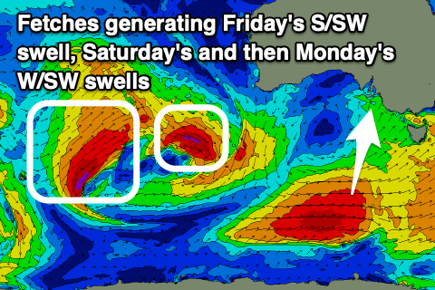 The groundswell is being generated by a strong polar front that's currently moving east-northeast, south of the country while generating a fetch of W/SW gales.
The swell should fill in through the afternoon, with the morning being around 3ft off Middleton, building to a good 4ft into the afternoon with moderate to fresh N/NE winds, easing through the day. The Mid Coast looks to be remain tiny.
Friday's swell will ease back through Saturday from 2-3ft off Middleton under fresh and gusty but easing N tending N/NW winds, while the Mid Coast should see an inconsistent new W/SW groundswell. This swell is being generated by a tight and intense mid-latitude low that's currently south-west of WA.
A fetch of W/SW gales are being aimed through our western swell window, providing 2ft sets on the favourable parts of the tide, but with bumpy to choppy conditions.
The swell will ease into Sunday, but later in the day a new, slightly better pulse of W/SW groundswell should be seen, generated by a more sustained fetch of W/SW gales in our western swell window, just behind the current mid-latitude low.
The swell may be seen later Sunday to 1-2ft on the Mid Coast, but Monday should provide good 2ft+ waves with 3ft sets more than likely on the favourable parts of the tide.
The South Coast won't see too much size with the westerly swell angle, with Sunday coming in at a small 1-2ft off Middleton, better Monday and to 2-3ft, but inconsistent.
Winds will swing from NW to SW with a passing front on Sunday, with Monday looking the pick as the swell peaks with early NE-N/NE winds on the Mid, W'ly into the afternoon but only moderate and N/NE tending W/NW winds down South.
It looks like winds might return to the NE on Tuesday as the W/SW groundswell eases from 2ft on the Mid Coast and 2ft off Middleton.
Longer term, weakening mid-latitude frontal activity dipping down from Western Australia looks to produce small pulses of W/SW swell with unfavourable winds later in the week for the South Coast, but more on this next update.
Comments
Hi Craig
I notice the Cape de Couedic wave graph on BOM now plots 'Dominant wave direction and spread'. Is this new and do you know is this an update to the buoy itself and how accurate the direction might be?
Thanks
Hi Charles, just writing an article about it right this second. Will be up today.
Cool thanks mate.
I was thinking the graph would be clearer if the direction only varied from south to west - being SA that's about it. Then I noticed the table of actual values :)
Looking forward to your article. Cheers