Great weekend down South, average until late next week

South Australian Forecast by Craig Brokensha (issued Friday 26th July)
Best Days: Keen surfers Mid Coast tomorrow and Sunday, South Coast all weekend, South Coast later next week
Recap
Good waves on the Mid Coast early yesterday with 2ft of swell and N/NE winds, choppy and poor into the afternoon with a gusty N/NW breeze. The South Coast was great all day with clean 3ft waves off Middleton, and bigger more challenging waves at Waits and Parsons.
Today the swell was a similar size on the South Coast, and back to 1-2ft on the Mid Coast with early variable winds, giving into a S'ly change, S/SE on the Mid Coast.
Today’s Forecaster Notes are brought to you by Rip Curl
This weekend and next week (Jul 27 – Aug 2)
We've got a fun weekend of waves on the cards, mostly for the South Coast with reinforcing pulses of W/SW-SW swell and favourable winds.
 The swell will ease back a touch into tomorrow, but we should still see 3ft sets off Middleton, though a little less consistent. The Mid Coast looks to be back to 1-1.5ft, with the outside chance for 2ft'ers on the favourable parts of the tide.
Conditions will be favourable for both coasts tomorrow morning with local offshore winds (N/NE South Coast and E/NE Mid Coast), tending W/NW into the afternoon and possibly giving into a SW sea breeze late afternoon down South.
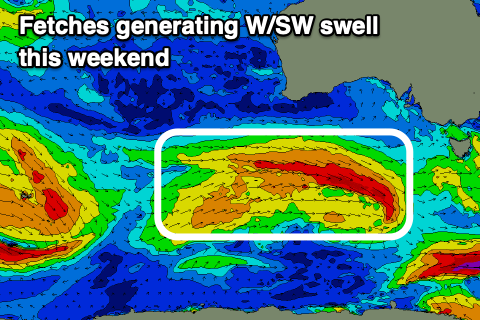
Later tomorrow and more so Saturday a new W/SW groundswell is due, generated by a pre-frontal fetch of W/NW gales moving in under WA today, through our western/south-western swell window. The slightly better and strengthening post-frontal W/SW fetch flagged on Wednesday now looks weaker and instead of a bigger increase in size on Monday, we'll see another pre-frontal W/NW fetch providing another a smaller SW swell for Monday morning.
Size wise Middleton looks to persist around a good 3ft Sunday, if not for the rare bigger one, and 1-1.5ft in the Mid Coast, with the odd 2ft'er on the favourable parts of the tide, easing Monday from 2-3ft and 1-1.5ft respectively.
Winds on Sunday will persist out of the N/NE across the South Coast, NE on the Mid ahead of sea breezes and then a trough moving through into the evening will bring poor and fresh SE winds Monday.
Winds will persist out of the E/SE Tuesday morning down South with a mix of long-range and inconsistent SW groundswell along with a S'ly groundswell from a low forming south-southwest of Tassie on Sunday evening. The Mid Coast will be clean but on the tiny side and back to 1ft.
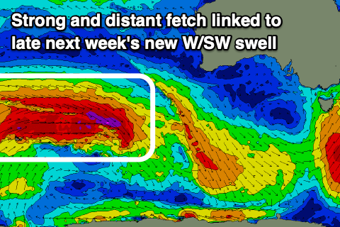 Longer term we've got a long-range and inconsistent but fun sized W/SW groundswell due into the end of the week, with it being a slightly more prolonged event, holding into next Saturday.
There'll actually be two swell pulses, with a strong and multi-staged polar frontal progression rolling east through the southern Indian Ocean from today through early next week. Various fetches of severe-gale W/SW winds will be generated, possibly even reaching storm-force at stages, generating large surf for WA and Indonesia but a less consistent and moderate sized increase across our region.
The swell may be seen later Thursday but Friday is the pick with inconsistent but strong 3-4ft sets off Middleton, 1ft to maybe 2ft on the Mid Coast and with great offshore N'ly winds. The swell should hold into Saturday morning before easing as N/NE winds persist. More on this Monday though, have a great weekend!