Building westerly swells late week, peaking on the weekend

South Australian Forecast by Craig Brokensha (issued Monday 24th June)
Best Days: South Coast late Thursday but more so Friday, Saturday and Sunday protected spots down South
Recap
Tiny Mid Coast waves all weekend, while an inconsistent new SW groundswell for the South Coast came in a little earlier than expected with great clean 2-3ft surf off Middleton Saturday morning, peaking into the afternoon.
Sunday was good again with the swell persisting at 2-3ft, easing through the day and tiny into today and back to 1-1.5ft off Middleton but with excellent conditions.
Today’s Forecaster Notes are brought to you by Rip Curl
This week and weekend (Jun 25 - 30)
As touched on the last couple of updates, this coming week will be void of any major surf until Thursday and more so Friday/Saturday.
The cause is a large and dominating high pressure system that has been sitting across our major swell windows, and is now located at 1036hPa just east of Victoria
 This is the yin to the yang in the southern Indian Ocean, with a significant and sustained frontal progression taking place through the weekend and into this morning.
This will be the source of the swell later week, but before this, we'll see the South Coast become tiny to flat but with great conditions. If you're desperate for a surf Waits and Parsons may see very infrequent 1-2ft sets tomorrow and Wednesday, but keep your expectations low.
A persistent northerly offshore will keep conditions clean across the magnets all day both days.
The swell due late week and into the start of the weekend is a tricky one with it being quite west in nature and having a couple of varying pulses.
Firstly, we've seen a broad and significant fetch of severe-gale W/SW winds generated in our far swell window, east-northeast of Heard Island. This has produced an inconsistent and long-range W/SW groundswell that should be seen late Thursday but will peak Friday morning.
The Mid Coast should see inconsistent sets to 1ft to maybe 2ft Friday, while Middleton looks small and inconsistent with 2ft to possibly 3ft sets across the stretch to Goolwa.
Winds will become an issue and be fresh and gusty out of the N/NE tending N on Friday, favouring the South Coast but creating poor conditions on the Mid.
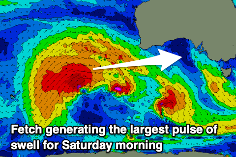
A secondary intensification of severe-gale to near storm-force W/SW winds at a more northern latitude will produce a slightly bigger but more W'ly angled swell for late Friday but more so Saturday morning.
Better 2-3ft sets are due across the Mid Coast Saturday when the swell peaks, with the South Coast coming in more around 3ft+ across the Middleton stretch, but a shift in winds to the W/NW will only favour protected spots down South.
The change in wind will be linked to a weak front moving under us, producing a small W/SW windswell for Sunday. This will be below the size of the easing W/SW groundswell and it looks like W/NW winds will continue to favour the South Coast.
Longer term we'll see the Long Wave Trough move in from the west and strengthening across the south-east of the country, bringing a flurry of vigorous fronts through our swell window under the country. This will generate large surf mid-next week, but the local winds are still up for grabs so check back over the coming week for updates.
Comments
Ha! So the mid coast once again snatches defeat from the jaws of victory! Was surprised when last weeks call was for 3ft plus this Friday with the chance of a nor-easter and I had everything crossed it might stay that way...but no....the mid never really seems to do it in winter....the swell always comes with the nor-wester.
Last wednesday was super clean pulsing 2-3ft in the morning even Freds turned on for a few hours. Swellnet's models for the mid almost always seem wrong regarding wind.
Yeah the wind is where the virtual buoy location is, which is more on the North Coast for KI, so you're better off getting the winds from my notes here.
Ok thanks now that makes more sense. Friday I reckon still has potential to be semi-clean 2-3ft, still a long way off. Tues/Wed looking like a stronger swell and more favourable winds!
Friday winds yes, not too bad, but the swell is the issue, arrival looks later than anything..
:(