Good swells and winds persist, large into next week

South Australian Forecast by Craig Brokensha (issued Wednesday 22nd May)
Best Days: South Coast every day this period, Mid Coast tomorrow afternoon
Recap
Great conditions across swell magnets on the South Coast yesterday with an inconsistent S/SW groundswell, coming in around the 2ft range off Middleton. The Mid Coast was clean and easing from 1-1.5ft.
Today the South Coast was clean again but small and easing, with the Mid Coast still picking up 1ft+ sets across magnets.
Today’s Forecaster Notes are brought to you by Rip Curl
This week and weekend (May 23 – 26)
From tomorrow our new building mid-period W/SW swell will fill in, followed by stronger and bigger levels of groundswell later in the afternoon, holding Friday.
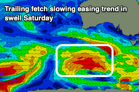 A broad and slow moving polar front pushing up towards WA and then slowly east towards us while weakening has generated this mix of swells. The storm is currently south of WA though we'll see one final intensification on its tail, generating a fetch of slow moving W/SW gales more in our south-western swell window. This will produce a reinforcing SW swell for Friday afternoon, slowing the easing trend Saturday.
Middleton looks to be around 2ft+ tomorrow morning, building later to 3ft+ if not more 3-4ft, while the Mid Coast should reach 2-3ft with the help of the incoming afternoon tide, much smaller in the morning.
Friday looks to be a tad smaller on the Mid and around 2ft+, easing from 1-2ft on Saturday. The South Coast should see 3-4ft sets off Middleton, easing back from 3ft to possibly 4ft Saturday morning.
Now, winds will be great for the South Coast through this period and from the N/NE tending N/NW tomorrow, fresher N/NW tending W/NW on Friday and then similar NW tending W/NW on Saturday.
The Mid Coast will be best tomorrow with a morning E/NE breeze, swinging light to moderate NW into the afternoon, more variable later.
A new pulse of W/SW-SW groundswell is due on Sunday, generated by a small and tight low moving in under the country tomorrow afternoon and Friday.
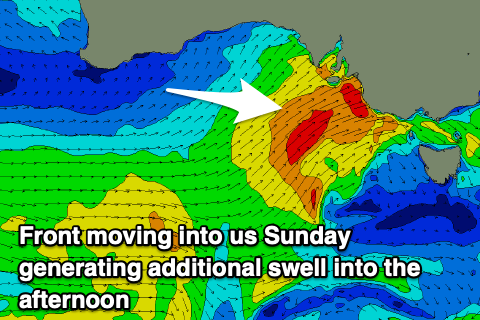 A very small fetch of gale to severe-gale W/SW winds will be projected towards us, weakening south-west of us Friday evening, with the swell due to peak Sunday morning to 3ft+ off Middleton and 2ft on the Mid Coast. This will be quickly be overridden by an additional close-range SW swell from a secondary front firing up on the back of the small low, projecting a fetch of strong to gale-force SW winds up and into us during the day Sunday.
An additional increase in size to 4-5ft off Middleton and a windy 3ft on the Mid Coast with strong W tending W/SW winds.
Monday looks better as the mix of swells ease under a W/NW offshore across the South Coast with plenty of size on offer early.
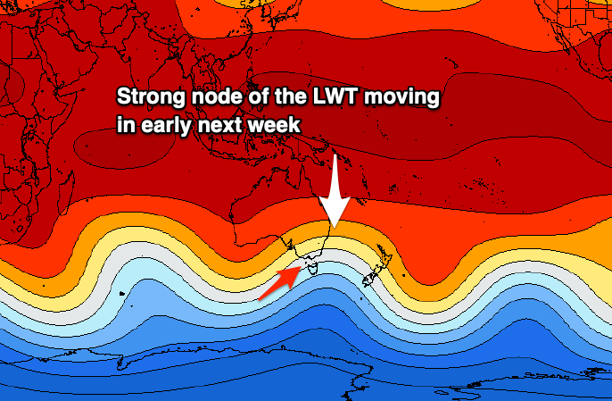 Of greater importance is a large and powerful S/SW groundswell event that's expected through mid-next week owing to a strong and pronounced node of the Long Wave Trough developing across the south-east corner of the country. This will bring back to back cold fronts, snow to the mountains and the first proper cold outbreak for the year.
In the Southern Ocean we'll see a broad and elongated polar front projecting a fetch of severe-gale to storm-force SW-S/SW winds through our southern swell windows for a significant amount of time, as the LWT remains slow moving. We're expected to see a large and long-period S/SW groundswell event building Tuesday and peaking Wednesday but with strong W/SW-SW winds. We'll have a closer look at this Friday though.
Comments
What's the size looking like for tmrw morning on the mid? 2ft?
1-2ft if we're lucky.
better than flat I suppose
was interesting this morning, it looked like trigs began to pulse to 2ft this morning at mid tide on like 1.6m of WSW swell
Yeah I know... threw me, not sure where that came from..
Was kind of a cross over swell? The Trough had peaks and small groundswell waves early. Quite unusual!
Ah I think I've found the source, this brief fetch of strong W/SW winds under WA on Monday morning just ahead of the strong storm generating tomorrow's swells.
Good signs for tomorrow to be 2ft on the sets with the activity behind it.
Couple of models showing a small pulse in the morning before the swell builds again in the arvo as well? Will some swell have arrived by the morning when the winds are NE
Yeah
Cheers might have a cheeky paddle