Large swells on the way with improving winds

South Australian Forecast by Craig Brokensha (issued Wednesday 8th May)
Best Days: Protected spots South Coast Sunday, keen surfers on the Mid into the afternoon and Monday morning, Monday down South and Tuesday morning down South
Recap
Tiny clean waves yesterday morning down South, choppy and poor into the afternoon with a westerly change and building windswell on the Mid Coast. Today there was a touch more swell on offer down South, but W/NW winds created bumpy conditions while the Mid Coast was a poor onshore 2ft.
Today’s Forecaster Notes are brought to you by Rip Curl
This week and weekend (May 9 – 12)
Tomorrow will remain poor across all coasts with a mix of windswell and inconsistent long-range W/SW groundswell but with a strong SW change moving through shortly after dawn.
This change will be linked to a weakening cold front moving in from the south-west, with a good increase in new SW groundswell due off it into Friday. The front is currently south of WA and projecting a fetch of strong to near gale-force W/SW winds through our south-western swell window, with strong SW winds in our western swell window.
 The Mid Coast should build to 2-3ft on Friday but with fresh to strong S/SW winds, while Middleton should build to 3-5ft, though with those poor winds.
Winds will try and improve and swing more W/SW on Saturday with an early W'ly unlikely around Victor. Friday's swell should ease back from 3ft+ off Middleton, with the Mid Coast dropping back from 1-2ft.
Sunday's new S/SW groundswell has been upgraded in size, with our secondary pulse for Monday still on the cards as well with favourable winds.
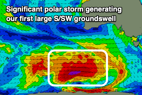
Sunday's will be generated by a broad and intense polar low that's forecast to develop east of Heard Island this evening, projecting a fetch of severe-gale to storm-force W'ly winds through our southern swell window, weakening a touch but still generating severe-gales along the polar shelf while tracking under the country Friday.
This will produce a large, long-period S/SW groundswell that's expected to arrive Sunday morning and build rapidly to 6ft off Middleton into the afternoon, with the Mid Coast building to 2ft.
 Winds are looking best for protected spots and out of the W/NW most of Sunday, not too strong on the Mid though still bumpy.
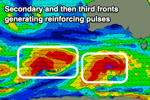
A secondary reinforcing S/SW groundswell is due on Monday, generated by a secondary polar front producing a burst of severe-gale to possibly storm-force W'ly winds on top the active sea state. This should keep Middleton up around 6ft on the sets Monday morning, easing through the day, with easing 2ft sets on the Mid Coast.
This looks to be the best day on the South Coat with excellent offshore N/NW winds, swinging more W/NW into the mid-late afternoon. The Mid Coast will likely see an early N/NE breeze and workable conditions.
Longer term another good sized reinforcing SW groundswell is due on Tuesday with a light morning W/NW breeze, followed by mornings of light winds and some new swell on the cards for late week. More on this Friday though.