Cold and windy week, improving from the weekend

South Australian Forecast by Craig Brokensha (issued Monday 6th May)
Best Days: Later Wednesday for desperate surfers on the South Coast, Saturday and Sunday mornings on the South Coast, Monday morning Mid Coast and all day down South
Recap
Fun and lumpy waves to 1-2ft on the Mid Coast Saturday with a light morning offshore, while the South Coast remained bumpy and onshore.
Sunday offered the best waves down South with a touch more swell, cleaner and improving conditions and fun waves from Middleton to Parsons as the Mid Coast became tiny.
Today we're back to smaller though clean surf suited to Waits and Parsons down South, flat on the Mid Coast.
Today’s Forecaster Notes are brought to you by Rip Curl
This week and weekend (May 7 – 12)
Currently a weak mid-latitude front is passing under WA through our western swell window, generating a fetch of 25-30kt W/SW winds.
This front will move in tomorrow bringing strengthening N/NW winds ahead of a shift to the W/NW into the afternoon and late and stronger W/SW change.
The surf will be tiny ahead of the change with no recommendations down South, while the Mid Coast will see a building windswell to an easy 2ft into the afternoon if not head-high 3ft sets on dark.
Wednesday should see easing 2ft to possibly 3ft sets on the Mid Coast along with fresh onshore W/SW winds, tending back to the W/NW through the afternoon with another approaching front. This should create improving conditions on the South Coast, but size wise there isn't anything too significant due with small weak easing sets from 2ft off 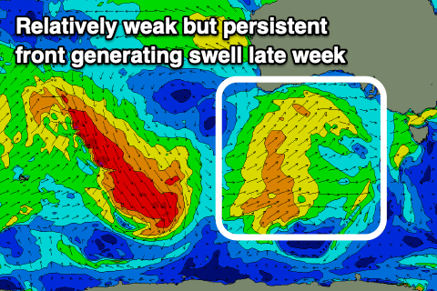 Middleton.
This next approaching front will projecting a broadening and strengthening fetch of W/SW-SW winds up through our western and then south-western swell window mid-week, generating a poor quality and building windswell Thursday ahead of some better groundswell on Friday.
Moderate to fresh and strengthening SW winds will create poor conditions on Thursday with building semi-stormy surf to 3ft+ later in the day on the Mid Coast and 3-4ft down South, while Friday should see stronger sets developing to 4-5ft through the day off Middleton.
The Mid Coast looks to persist around 3ft but conditions will remain poor with strong and easing S/SW winds.
The surf is expected to start easing on Saturday but winds look to linger out of the W/SW, with an outside chance of a morning W'ly around Victor.
 Sunday morning should be clean with an early W/NW breeze, though we'll be in between swells with Middleton expected to be around 3ft (our models are incorrectly combining an inconsistent long-range swell and mid-period local energy).
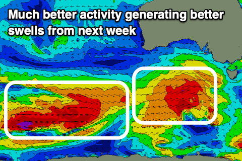
Into the afternoon though and more so Monday morning a mix of new SW groundswells are due to fill in, generated by pre-frontal NW fetches and polar W/SW fetches, the later producing the best swell for Monday.
Middleton should offer good 4-5ft sets on Monday morning with 1-2ft sets on the Mid Coast and great N/NW offshore winds, swinging W/NW later. The Mid Coast may see an early N/NE'ly, but we'll review this Wednesday.
Beyond this the westerly storm track looks to become over active, generating plenty of swell for the rest of next week with generally light winds. More on this Wednesday.
Comments
Is the wind ever going to go offshore in a swell over 2ft on the mid...farks sake
Probably not.