Clean easing surf, new W/SW swells from early-mid next week

South Australian Forecast by Craig Brokensha (issued Friday 12th October)
Best Days: Swell magnets South Coast Saturday, both coasts Thursday, South Coast swell magnets Friday
Recap
A slight improvement in the surf yesterday down South as winds eased off and tended more E'ly, back to the S'th into the afternoon. The Mid Coast was flat and clean, increasing very slightly through the afternoon but with a sea breees.
Today conditions are cleaning up nicely down South with a leftover S/SE windswell in the 2-3ft range at magnets. A stronger new SW groundswell should fill in this afternoon and provide infrequent 3ft sets off Middleton as winds swing back to the S/SE.
Today’s Forecaster Notes are brought to you by Rip Curl
This weekend and next week (Oct 13 – 19)
This afternoon's new SW groundswell is due to ease out of the S/SW tomorrow and conditions will be good across more exposed south-west facing breaks with a moderate to fresh NE breeze that will likely tend E/NE later in the day.
Middleton is only due to ease from 2ft+, better at swell magnets and flat on the Mid Coast.
Sunday will be cleaner with a N/NE offshore but no size left, tiny off Middleton and best left to beginners, with even small to tiny surf at Waits and Parsons.
 We'll see the swell remain minimal before a new inconsistent W/SW groundswell fills in later Tuesday and more so Wednesday followed by a better pulse on Thursday.
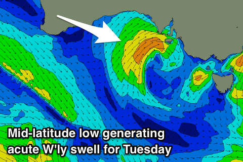
The Mid Coast will actually see a mid-period W'ly swell fill in ahead of these swells during Tuesday, as a weak mid-latitude low forms in the Bight on Sunday evening, producing a small slither of strong W/SW winds just in its swell window, moving east and across us slowly Tuesday.
A building W'ly swell to 2-3ft is expected into the afternoon, smaller and to 2ft into the morning. Winds will be average though and moderate to fresh from the W tending W/SW. This swell will be too west in nature initially for the South Coast with a possible late kick in size Tuesday, but a stronger groundswell will be in the mix.
The W/SW groundswell will be generated by a distant polar low that formed in the Heard Island region earlier this week, with a distant fetch of W/SW gales produced in our western swell window.
The size for the Mid Coast will be smaller than the locally generated W'ly swell, while Middleton should build to 2ft later in the day Tuesday, holding a similar size into Wednesday morning.
Winds on Wednesday will unfortunately be onshore as the low pushes slowly further east bringing SW tending S/SW winds.
Thursday's stronger W/SW groundswell will be generated by the most significant of the storms firing up south-west of WA this weekend.
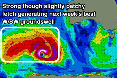 We'll see a pre-frontal fetch of severe-gale W/NW winds immediately followed by post-frontal (though patchy) severe-gale to storm-force W/SW winds in our western swell window, generating a moderate sized long-period W/SW groundswell for later Wednesday, peaking Thursday.
The Mid Coast should come in at 2ft+ on the favourable parts of the tide, while Middleton is looking to be more around 3ft, with hopefully better E/NE-NE winds as a strong high quickly moves in from the west.
Friday is looking better across swell magnets on the South Coast with a N'ly offshore and easing 2ft+ sets off Middleton, but we'll review this.
Longer term we may see further W/SW swells into next weekend and early the following week, but more on this Monday. Have a great weekend!