Funky winds over the coming period with long-range swells

South Australian Forecast by Craig Brokensha (issued Wednesday 22nd August)
Best Days: Early tomorrow South Coast magnets, keen surfers Friday both coasts and Saturday morning South Coast, Sunday South Coast
Recap
A good start to the South Coast yesterday with some new swell and favourable winds, but a stronger SW groundswell kicked in as forecast through the afternoon (image below) providing great waves as winds held out of the W/NW.

This morning the swell was on the ease but great again with 3-4ft waves off Middleton with an offshore wind which has straightened even further with a further drop in size. The Mid Coast has been tiny the last couple of days, cleanest this morning.
Today’s Forecaster Notes are brought to you by Rip Curl
This week and weekend (Aug 23 - 26)
The swell is expected to reach a low point through tomorrow but the South Coast will be fun at magnets early and Goolwa with a moderate to fresh N/NE breeze, tending NE-E/NE by mid-morning creating deteriorating conditions, worse into the afternoon as winds go more E/SE. The Mid Coast will be clean but tiny.
Our new long-period and very inconsistent W/SW groundswell for Friday is still on track along with the less than ideal winds from the eastern quadrant.
 The swell was generated by a vigorous polar low in the southern Indian Ocean over the weekend, breaking down south-west of WA on Monday.
Due to the large distance between the source of the swell and our coasts, there'll be long waits between sets, but we should see Middleton come in at 3ft to occasionally 4ft all Friday, with 1-1.5ft sets on the favourable parts of the tide on the Mid Coast.
A wandering cut-off low will bring funky E/NE tending SE winds on Friday, similar but lighter on Saturday.
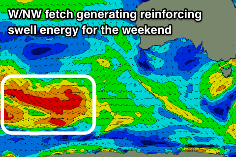
A secondary pulse of reinforcing SW groundswell is due to fill in on Saturday, generated by a weaker but closer positioned fetch of pre-frontal W/NW gales moving through our south-western swell window, in the south-east Indian Ocean the last couple of days.
The swell looks a touch smaller but a little more consistent with 3ft surf off Middleton Saturday and Sunday, easing into Monday. This reinforcing energy isn't looking as favourably aligned for the Mid Coast, with tiny 1ft waves due.
The larger sizes shown on the Middleton forecast charts for Sunday is wrong and due to an incorrect combination of very long-range long-period swell with no size, with the existing swell.
Winds are looking better on Sunday and light offshore out of the N/NW, tending more W/NW into the afternoon.
Moving into next week it looks like we'll see the surf slowly easing as winds deteriorate as the wandering low continues east and merges with a weak polar front, resulting in the formation of a deeper low off the Gippsland coast. This may bring strengthening SE winds on Monday, more E/SE Tuesday and Wednesday, but we'll have a closer look at this Friday.