Good easing swell with mixed conditions - upgrade in swell for the weekend

South Australian Forecast by Craig Brokensha (issued Wednesday 15th August)
Best Days: Protected spots South Coast tomorrow, South Coast Friday morning, South Coast Monday through mid-next week
Recap
Great waves most of the day yesterday across the South Coast with a reinforcing W/SW swell and 2-3ft sets off Middleton, small to tiny on the Mid Coast. This morning the swell has bottomed out with leftover 2ft sets off Middleton and choppy 1-2ft waves at magnets on the Mid Coast.
Some new W/SW swell is currently on the build from a strong mid-latitude storm that's pushing under us, but more on this below.
Today’s Forecaster Notes are brought to you by Rip Curl
This week and weekend (Aug 16 - 19)
The last day or so, a strong mid-latitude storm formed south-west of WA and pushed east through the Bight while generating a fetch of severe-gale W/SW winds.
This system is now passing across and under us, on its way to Victoria, with an increase in W/SW swells due through this afternoon, peaking early tomorrow morning before easing slowly through the day.
The Mid Coast should see 2-3ft surf, easing through the day, while the Middleton stretch looks to come in around 4ft on the sets. Winds should hold out of the W/NW all day across the South Coast, with W/SW tending W winds on the Mid Coast.
 Friday will see the surf continuing to ease but with great conditions down South with a strengthening NW tending W/NW breeze. Middleton looks to ease back from 3ft on the sets (mostly 2-3ft) with 1-2ft waves on the Mid Coast.
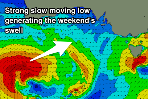
Moving into the weekend, and we've had an upgrade in swell due across the state, with the strengthening polar front actually forming east of Heard Island yesterday.
We'll see this polar front move very slowly while generating a great fetch of gale to severe-gale W/SW winds through our western swell window, weakening gradually while projecting more through our south-western swell window, passing under through Saturday.
We should see a moderate to large sized W/SW tending SW groundswell generated, building through Saturday, easing Sunday as a reinforcing S/SW pulse fills in.
The only problem are the local winds, with an early W/NW offshore due to swing W/SW-SW across the South Coast Saturday and remain fresh to strong out of the S/SW on Sunday.
Size wise, Middleton should build to 4-5ft+ by dark on Saturday, much smaller early and more so 2ft. The Mid Coast looks to offer 1-2ft of windswell, with the groundswell building more to 2ft+ later in the day and holding 2ft Sunday. Middleton will be a mess on Sunday and coming in around the 4ft range.
Looking into Monday and the swell will ease out of the S/SW and we're likely to see more variable winds across the South Coast, creating cleaner conditions.
Longer term a fun new S/SW groundswell with favourable offshore N'th winds is likely mid-week, but we'll have a closer look at this on Friday.
Comments
Flipper isn't looking too healthy :o
Is that another shark in its mouth or a dolphin?!
Dolphin, it's just upside down.