Large westerly swells inbound

South Australian Forecast by Craig Brokensha (issued Monday 23rd July)
Best Days: South Coast tomorrow, both coasts Wednesday, South Coast Thursday and Friday morning
Recap
Pumping South Coast waves Saturday with a strong easing S/SW groundswell while the Mid Coast had OK leftover 1-2ft surf.
Sunday was smaller and best at swell magnets down South, tiny on the Mid. Some new W/SW swell has filled in today to 1-2ft on the Mid Coast with a northerly breeze, small to tiny down South.
Today’s Forecaster Notes are brought to you by Rip Curl
This week and weekend (Jul 24 - 29)
Want to receive an email when these Forecaster Notes are updated? Then log in here and update your preferences.
Currently a vigorous frontal system is pushing through the Bight towards us, spawning off the progression that's set in motion the largest swell of the season for Indonesia.
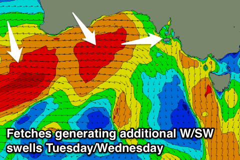 The swell is impacting WA with XXL stormy surf, and we'll see the groundswell from this progression building through tomorrow and peaking Wednesday, but with solid levels of W/SW swell from the systems pushing through the Bight also in the mix.
The Mid Coast will see strong 3-4ft surf on the favourable parts of the tide tomorrow from the storm pushing through the Bight, along with poor strong NW winds, shifting more W/NW through the afternoon.
This will favour the South Coast, but the swell will be smaller and very west, and the models are incorrectly combining lots of different energy again, over-forecasting the size.
We'll likely see Middleton coming in around 3ft, building more towards 4ft later in the day (much bigger at Goolwa with the westerly direction).
Come Wednesday we're looking at more size up towards 4-5ft+ across Middleton. The Mid Coast looks to hang in at 3ft to occasionally 4ft and we'll see conditions improve rapidly through the day as a strong high moves in quickly from the west.
This will create light variable winds on the Mid Coast (possibly W'ly at dawn), and light W/NW tending variable winds on the South Coast.
We'll see the surf easing off into the end of the week, slowed slightly by a reinforcing S/SW swell Thursday afternoon, generated by a slow moving fetch of W/SW gales south of us tomorrow evening.
Conditions will be great down South with a fresh N/NE offshore, possibly tending more NE into the afternoon as a mid-latitude low wanders in from the west.
Middleton looks to drop back from the 4ft range, with easing 2ft waves on the Mid Coast, while Friday will see smaller easing waves with W/NW tending S winds as the low moves across us.
The start of the weekend isn't looking too flash at the moment with a low point in swell and winds out of the west, but another long-period though inconsistent W/SW groundswell is due build into the afternoon, peaking Monday with favourable winds.
The storm generating this swell will be in our far swell window before weakening while pushing closer towards WA later this week, but we'll have a closer look at this Wednesday.