Good swells this week with varying winds

South Australian Forecast by Craig Brokensha (issued Monday 12th February)
Best Days: Both coasts tomorrow, Mid Coast later Wednesday, both coasts Thursday morning, South Coast Friday and Saturday mornings
Recap
Small clean waves across both coasts on Saturday morning with some fun swell hanging in on the Mid and decent waves at magnets down South.
Sunday was OK as well down South with a lift in swell with workable light winds while the Mid was tiny. This morning light winds again created OK conditions down South with some fun sets off Middleton, 1ft on the Mid.
Today’s Forecaster Notes are brought to you by Rip Curl
This week and weekend (Feb 13 - 18)
As touched on last week, we've got plenty of swell on the cards for this week, owing to a strengthening node of the Long Wave Trough moving slowly in from the Bight, bringing with it a flurry of frontal activity.
Into tomorrow we're due to see the first increase in mid-period SW swell, produced over the weekend by a weakening front pushing in from under WA.
This front started as a strong polar low in the Heard Island region, with that inconsistent long-period energy due to fill in Wednesday.
But coming back to tomorrow and the Mid Coast should see 1-2ft sets on the favourable parts of the tide, with Middleton building to a good 3ft+ through the day.
Conditions are looking great for both regions with variable tending locally offshore N/NE winds, variable early afternoon ahead of late sea breezes.
The less consistent long-period energy should peak Wednesday morning, more to 3ft off Middleton with 1-1.5ft sets on the Mid Coast, but into the afternoon some new SW swell is due, produced by secondary front that's currently developing south-west of WA.
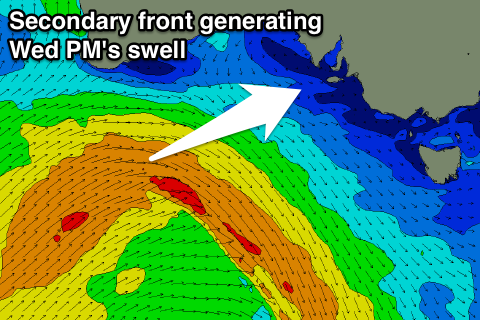 This front will project a fetch of strong to gale-force W/SW winds through our western and then south-western swell windows today and tomorrow, with the Mid Coast due to kick to 2ft+ into the afternoon with 3-4ft sets off Middleton.
Winds however will be average with a dawn W/NW breeze due to swing SW with the change shortly thereafter, therefore the window of clean conditions is very minimal, and possibly not there at all.
The Mid Coast will likely see winds tend S/SE later in the day, creating improving conditions.
Come Thursday another front passing under us will generating some reinforcing SW swell for the South Coast, keeping wave heights steady around 3-4ft all day off Middleton before easing into the afternoon.
The Mid should be around 2ft, easing through the day ahead of the incoming afternoon push keeping sets at 1-2ft. Winds look variable and light W/NW down South through the morning and S/SE on the Mid Coast creating good conditions before tending onshore.
Friday looks similar, while Saturday morning should also see a morning W/NW breeze down South as the swell continues to ease.
Moving into Sunday onshore SE winds are due to kick back in as a high slides in from the west, along with no major new swells.
Comments
Nice lines at Middleton this morning.

That front has come close to the coast........how big will this monster summer swell be.......?