Average weekend, better swells next week

South Australian Forecast by Craig Brokensha (issued Wednesday 7th February)
Best Days: Desperate surfers early tomorrow South Coast, both coasts Tuesday, South Coast Wednesday morning
Recap
No swell across both coasts yesterday morning, but into the afternoon, our new W/SW groundswell pulse due across the Mid Coast came in right on cue with most spots seeing 1-1.5ft waves into the evening, with 2ft sets at magnets.
This morning the swell was a similar size, though the outgoing tide has pulled back the consistency a little. We should see it kick again this afternoon/evening before the swell fades into the weekend.
The South Coast also saw a small increase in swell, best at swell magnets with a morning offshore.

Today’s Forecaster Notes are brought to you by Rip Curl
This weekend and next week (Feb 10 - 16)
The W/SW swell seen the last couple of days should ease back from a tiny 1ft on the Mid Coast tomorrow, while a small SW groundswell should keep 1-2ft sets hitting Middleton.
Variable winds are expected early tomorrow morning with clean conditions though an onshore change is due late morning, so don't dawdle.
This change will create poor conditions into Sunday with S'ly tending S/SW winds on the South Coast, while the Mid will be cross-shore, before the S/SW'ly kicks in.
 The Mid Coast is due to be tiny, but later in the day and more so Monday some tiny new W/SW swell is due.
This is being generated by a weak front that's currently passing south of WA and should provide 1ft sets later Sunday and Monday. Winds on Monday are looking a little dicey but land breezes should wind with a morning S/SE'ly ahead of sea breezes.
The South Coast may see a lingering S/SW breeze with small fading sets from 2ft at Middleton.
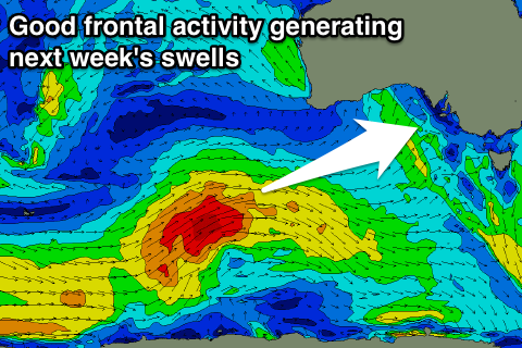
Of greater importance is the better swell energy due through the week, with a flurry of strong frontal activity through the Southern Ocean owing to a strong node of the Long Wave Trough strengthening through the Bight and moving east.
Currently we've seen a small strong polar low form south of Heard Island, with this system due to project east-northeast towards the Bight through today and the weekend, weakening south-west of us Sunday.
Wind speeds will initially be gale to severe-gale-force, weakening as the front gets closer.
Long-period less consistent swell energy will be generated for Wednesday morning, but through Tuesday mid-period energy will be seen arriving ahead of this, due to the front racing ahead of itself.
The mid-period energy will be better aligned for the Mid Coast rather than the long-period energy, with sets due to come in around 1-2ft on the favourable parts of the tide Tuesday, while Middleton should see 3ft+ waves.
The groundswell should come in at 3-4ft off Middleton Wednesday morning, while the Mid Coast will hanging in at 1-2ft, and a more consistent mid-period SW swell is due through the afternoon, produced by another mid-latitude front pushing up towards us early next week.
This should keep similar sized but more consistent sets across both coasts, with another possible swell for Thursday, but we'll have a closer look at all these embedded pulses on Monday.
Conditions are this stage look favourable with variable winds Tuesday morning and a W/NW tending SW breeze Wednesday, but check back Monday for confirmation. Have a great weekend!