Stormy waves tomorrow, cleaning up late week

South Australian Forecast by Craig Brokensha (issued Monday 17th July)
Best Days: Stormy haunts on the Mid Coast tomorrow, South Coast Thursday, Friday, Saturday and Sunday morning
Recap
Plenty of swell Saturday but conditions were a bit lumpy/bumpy early on the South Coast, improving through the day as winds tended more offshore. The Mid Coast eased back from a clean 2ft but was a little less consistent and a touch smaller than expected.
Sunday provided fun clean waves across the South Coast with all day offshores, while the Mid Coast saw bumpy and choppy 1-2ft surf.
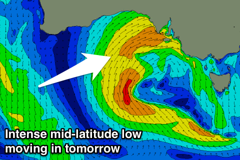
Today the swell has continued to bottom out down South with strong offshores, while the Mid Coast was tiny and bumpy early to 1-1.5ft but the northern flank of a strong mid-latitude low that's been moving in from the west has since moved in, kicking up a building stormy swell. We should see easy 3ft waves into this afternoon for desperate surfers.
This week and weekend (Jul 18 – 23)
The strong mid-latitude low currently passing across us will stall and project a fetch of strong W/SW winds across the gulfs this evening and tomorrow.
This will continue to generate large stormy waves on the Mid Coast to 3-4ft with strong W'ly winds, tending SW later in the day.
 The South Coast won't see too much size with the the lifetime of this mid-latitude low seeing W/SW fetches sitting just a touch too far north and out of our swell window.
Tomorrow morning, Middleton should see 3ft of W/SW swell but those strong W'ly winds will create a few issues before tending SW later.
This SW change will be related to the low pushing east and with this a broad fetch of S'ly winds will be projected up into the South Coast, bringing a solid stormy S'ly swell Wednesday morning to 4-6ft across Middleton.
The Mid Coast will ease back in size from 2ft to nearly 3ft along with fresh but easing SW tending S/SW winds.
A secondary polar front projecting up and through our southern swell window Wednesday and early Thursday should produced a reinforcing mid-period S'ly swell for Thursday afternoon, easing Friday.
We'll see the S'ly windswell from Thursday easing back from the 3ft+ range across most spots with variable winds, creating fun conditions. Friday should then see fun easing waves from 3ft with a fresh N/NE breeze.
The Mid Coast won't see any of this swell with fading 1ft+ waves Thursday, tiny Friday.
Into the weekend and early next week we'll see plenty more W/SW swell as the mid-latitude lows continue to form and push east from over near WA.
They're not looking as strong as the current setups but we should see a good run of W/SW swell for the Mid from Saturday through Monday although with onshore winds.
These swells won't be great for the South Coast and super west, but conditions will be cleaner in the region. More on this Wednesday.