Average end to the week, great Sunday

South Australian Forecast by Craig Brokensha (issued Wednesday 26th April)
Best Days: Protected spots South Coast Friday morning, south Coast Sunday and Monday morning
Recap
Tiny bumpy waves on the Mid Coast, while the South Coast saw fun waves in protected locations as winds held from the W-SW most of the day.
Overnight though a strong onshore SW change ripped through, kicking up 2ft of windswell across the Mid Coast and stormy 4-5ft waves down South.
This week and weekend (Apr 27 – 30)
The cold front responsible for today's stormy swell is moving off to the east, but we'll continue to see average onshore SW winds down South tomorrow, tending W/SW through the day.
A mix of groundswell and windswell should continue to provide plenty of size to 3-4ft off Middleton, easing through the afternoon and back to 2-3ft Friday morning.
The Mid Coast should persist around 1ft with possible early S'ly winds, similar Friday but with SW breezes.
 We should hopefully see more favourable W/NW breezes around Victor Friday morning, but Middleton will likely be the only decent option.
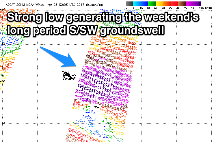
A low point in swell is due Saturday morning, around 2ft off Middleton, but later in the day, a strong new S/SW groundswell is due to arrive.
This swell has already started to be generated, and will continue to be through until tomorrow morning by a vigorous low forming in the southern Indian Ocean. A fetch of severe-gale to storm-force W/NW winds formed north-west of Heard Island, projected south-east towards the polar shelf through our southern swell window.
We'll see this groundswell arriving later in the day Saturday, building to 3-4ft across Middleton, easing Sunday morning from 3-4ft+. The Mid Coast isn't due to see much size, with tiny 0.5-1ft sets max.
An early W/NW breeze is likely down South Saturday morning, onshore from the SW into the late morning, while Sunday will see offshore W/NW-NW winds all day as a strong polar front approaches. This will create great waves all day down South, offshore again Monday morning but smaller ahead of a strong S/SW change.
Into early next week, Monday's S/SW change will be related to a strong and slow moving cold outbreak, and with this we'll see embedded fronts continuing to project S/SW winds towards us Tuesday through Thursday. This will also spoil some fun sized S/SW swell, while the Mid Coast will remain tiny. More on this Friday though.